Mociūnai | |
|---|---|
Village | |
 | |
 Mociūnai Location in Lithuania | |
| Coordinates: 55°22′43″N 23°58′43″E / 55.37861°N 23.97861°E | |
| Country | |
| County | |
| Municipality | Kėdainiai district municipality |
| Eldership | Surviliškis Eldership |
| Population (2011) | |
| • Total | 28 |
| Time zone | UTC+2 (EET) |
| • Summer (DST) | UTC+3 (EEST) |
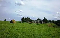
Mociūnai (formerly Polish: Maciuny,[1] Russian: Мацюны) is a village in Kėdainiai district municipality, in Kaunas County, in central Lithuania. According to the 2011 census, the village had a population of 28 people.[2] It is located 2.5 km from Kalnaberžė, by the deep valleys of Kruostas and Skaudinis rivers. There is an Old Believers cemetery in the village. Mociūnai Forest Botanical Sanctuary is located 2 km away from the village, in Kalnaberžė Forest.
Demography
|
| ||||||||||||||||||||||||||||||
| Source: 1902, 1923, 1959 & 1970, 1979, 1989, 2001, 2011 | |||||||||||||||||||||||||||||||
Images
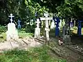 Old Believers cemetery
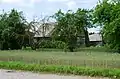 An abandoned house
 Mociūnai in winter
References
- ↑ "Maciuny". Geographical Dictionary of the Kingdom of Poland (in Polish). 5. Warszawa: Kasa im. Józefa Mianowskiego. 1884. p. 887.
- ↑ "2011 census". Statistikos Departamentas (Lithuania). Retrieved August 21, 2017.
This article is issued from Wikipedia. The text is licensed under Creative Commons - Attribution - Sharealike. Additional terms may apply for the media files.