Mojinete Municipality | |
|---|---|
Municipality | |
 Mojinete | |
 Location within Potosí Department | |
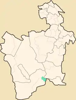
 Mojinete Municipality Location within Bolivia | |
| Coordinates: 21°46′S 66°18′W / 21.767°S 66.300°W | |
| Country | |
| Department | Potosí Department |
| Province | Sur Lípez Province |
| Seat | Mojinete |
| Elevation | 11,500 ft (3,500 m) |
| Population (2001) | |
| • Total | 716 |
| • Ethnicities | Quechua |
| Time zone | UTC-4 (BOT) |
Mojinete Municipality is the second municipal section of the Sur Lípez Province in the Potosí Department in Bolivia. Its seat is Mojinete.
Subdivision
The municipality consists of the following cantons:
- Bonete Palca
- Casa Grande
- Mojinete
- Pueblo Viejo
- La Cienega
The people
The people are predominantly indigenous citizens of Quechua descent.[1]
| Ethnic group | % |
|---|---|
| Quechua | 98.3 |
| Aymara | 1.0 |
| Guaraní, Chiquitos, Moxos | 0.0 |
| Not indigenous | 0.7 |
| Other indigenous groups | 0.0 |
References
- ↑ obd.descentralizacion.gov.bo/municipal/fichas/ (inactive)
External links
Capital: Potosí | ||
| Provinces | 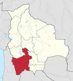 | |
| Municipalities (and seats) |
| |
This article is issued from Wikipedia. The text is licensed under Creative Commons - Attribution - Sharealike. Additional terms may apply for the media files.