Mothibistad | |
|---|---|
 Mothibistad  Mothibistad | |
| Coordinates: 27°23′56″S 23°29′20″E / 27.399°S 23.489°E | |
| Country | South Africa |
| Province | Northern Cape |
| District | John Taolo Gaetsewe |
| Municipality | Ga-Segonyana |
| Area | |
| • Total | 5.49 km2 (2.12 sq mi) |
| Population (2011)[1] | |
| • Total | 9,616 |
| • Density | 1,800/km2 (4,500/sq mi) |
| Racial makeup (2011) | |
| • Black African | 98.9% |
| • Coloured | 0.6% |
| • Indian/Asian | 0.4% |
| • Other | 0.2% |
| First languages (2011) | |
| • Tswana | 88.0% |
| • English | 3.0% |
| • S. Ndebele | 1.7% |
| • Zulu | 1.4% |
| • Other | 5.9% |
| Time zone | UTC+2 (SAST) |
| Area code | 053 |
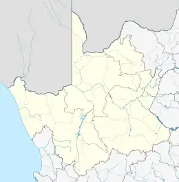
Mothibistad is a town situated 9 kilometres (6 mi) northeast of Kuruman in the Northern Cape province of South Africa. Before 1994 it was in the Bophuthatswana bantustan, and from 1994 until a border change in 2006 it was in North West province. According to the census of 2011 it had a population of 9,616, of whom 99% described themselves as Black African and 88% spoke Tswana as a first language.[1] It falls within the Ga-Segonyana Local Municipality and the John Taolo Gaetsewe District Municipality.
References
Municipalities and communities of John Taolo Gaetsewe District Municipality, Northern Cape | ||
|---|---|---|
District seat: Kuruman | ||
| Joe Morolong | .svg.png.webp) John Taolo Gaetsewe District within South Africa | |
| Ga-Segonyana | ||
| Gamagara | ||
This article is issued from Wikipedia. The text is licensed under Creative Commons - Attribution - Sharealike. Additional terms may apply for the media files.