| Mount Henry | |
|---|---|
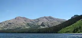 Appistoki at left and Mount Henry at right rise above Two Medicine Lake | |
| Highest point | |
| Elevation | 8,852 ft (2,698 m)[1] |
| Prominence | 1,367 ft (417 m)[1] |
| Coordinates | 48°27′12″N 113°20′36″W / 48.45333°N 113.34333°W[2] |
| Geography | |
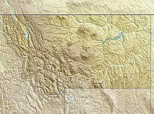 Mount Henry Location in Montana  Mount Henry Location in the United States | |
| Location | Glacier County, Montana, U.S. |
| Parent range | Lewis Range |
| Topo map | USGS Squaw Mountain, MT |
Mount Henry (8,852 feet (2,698 m)) is located in the Lewis Range, Glacier National Park in the U.S. state of Montana.[3] Mount Henry is just south of Appistoki Peak in the Two Medicine region of the park.
See also
References
- 1 2 "Mount Henry, Montana". Peakbagger.com. Retrieved August 9, 2017.
- ↑ "Mount Henry". Geographic Names Information System. United States Geological Survey, United States Department of the Interior. Retrieved August 9, 2017.
- ↑ Dancing Lady Mountain, MT (Map). TopoQwest (United States Geological Survey Maps). Retrieved August 9, 2017.
This article is issued from Wikipedia. The text is licensed under Creative Commons - Attribution - Sharealike. Additional terms may apply for the media files.