Mundo Novo | |
|---|---|
| The Municipality of Mundo Novo | |
 Flag  Seal | |
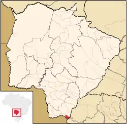 Location of Mundo Novo | |
| Coordinates: 23°56′16″S 54°16′15″W / 23.93778°S 54.27083°W | |
| Country | |
| Region | Central-West |
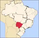
| State | |
| Founded | May 13, 1973 |
| Government | |
| • Mayor | Antonio Cavalcante |
| Area | |
| • Total | 479.327 km2 (185.069 sq mi) |
| Elevation | 324 m (1,063 ft) |
| Population (2020 [1]) | |
| • Total | 18,473 |
| • Density | 29.2/km2 (76/sq mi) |
| Time zone | UTC−4 (AMT) |
| HDI (2000) | 0.761 – medium[2] |
| Website | www.mundonovo.ms.gov.br/ |
Mundo Novo is the southernmost municipality in the Brazilian state of Mato Grosso do Sul. Its population was 18,473 (2020) and its area is 479.327 km².
References
Capital: Campo Grande | |||||||||
| Mesoregion Centro Norte de Mato Grosso do Sul |
|  | |||||||
| Mesoregion Leste de Mato Grosso do Sul |
| ||||||||
| Mesoregion Pantanal Sul Mato-Grossense |
| ||||||||
| Mesoregion Sudoeste de Mato Grosso do Sul |
| ||||||||
This article is issued from Wikipedia. The text is licensed under Creative Commons - Attribution - Sharealike. Additional terms may apply for the media files.