Mureils | |
|---|---|
Part of Saint-Jean-de-Galaure | |
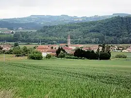 A general view of Mureils | |
Location of Mureils | |
 Mureils  Mureils | |
| Coordinates: 45°12′35″N 4°55′51″E / 45.2097°N 4.9308°E | |
| Country | France |
| Region | Auvergne-Rhône-Alpes |
| Department | Drôme |
| Arrondissement | Valence |
| Canton | Saint-Vallier |
| Commune | Saint-Jean-de-Galaure |
| Area 1 | 5.45 km2 (2.10 sq mi) |
| Population (2019)[1] | 473 |
| • Density | 87/km2 (220/sq mi) |
| Time zone | UTC+01:00 (CET) |
| • Summer (DST) | UTC+02:00 (CEST) |
| Postal code | 26240 |
| Elevation | 214–378 m (702–1,240 ft) (avg. 225 m or 738 ft) |
| 1 French Land Register data, which excludes lakes, ponds, glaciers > 1 km2 (0.386 sq mi or 247 acres) and river estuaries. | |
Mureils is a former commune in the Drôme department in southeastern France. On 1 January 2022, it was merged into the new commune of Saint-Jean-de-Galaure.[2]
Population
| Year | Pop. | ±% |
|---|---|---|
| 1911 | 395 | — |
| 1962 | 202 | −48.9% |
| 1968 | 246 | +21.8% |
| 1975 | 244 | −0.8% |
| 1982 | 234 | −4.1% |
| 1990 | 272 | +16.2% |
| 1999 | 307 | +12.9% |
| 2008 | 348 | +13.4% |
| 2019 | 473 | +35.9% |
Geography
The Galaure flows southwest through the southern part of the commune.
See also
References
- ↑ Téléchargement du fichier d'ensemble des populations légales en 2019, INSEE
- ↑ Arrêté préfectoral, p. 53, 19 October 2021 (in French)
Wikimedia Commons has media related to Mureils.
This article is issued from Wikipedia. The text is licensed under Creative Commons - Attribution - Sharealike. Additional terms may apply for the media files.