Nagyrada | |
|---|---|
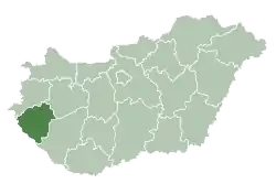
 Nagyrada Location of Nagyrada | |
| Coordinates: 46°37′17″N 17°06′40″E / 46.62138°N 17.11105°E | |
| Country | |
| County | Zala |
| Area | |
| • Total | 12.85 km2 (4.96 sq mi) |
| Population (2004) | |
| • Total | 533 |
| • Density | 41.47/km2 (107.4/sq mi) |
| Time zone | UTC+1 (CET) |
| • Summer (DST) | UTC+2 (CEST) |
| Postal code | 8746 |
| Area code | 93 |
Nagyrada is a village in Zala County, Hungary. It is bordered by Austria in the west.
External links
- Street map (in Hungarian)
.svg.png.webp)
This article is issued from Wikipedia. The text is licensed under Creative Commons - Attribution - Sharealike. Additional terms may apply for the media files.