Naizin
Neizin | |
|---|---|
Part of Évellys | |
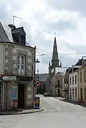 The main road in Naizin | |
Location of Naizin | |
 Naizin  Naizin | |
| Coordinates: 47°59′24″N 2°49′50″W / 47.99°N 2.8306°W | |
| Country | France |
| Region | Brittany |
| Department | Morbihan |
| Arrondissement | Pontivy |
| Canton | Grand-Champ |
| Commune | Évellys |
| Area 1 | 40.99 km2 (15.83 sq mi) |
| Population (2019)[1] | 1,808 |
| • Density | 44/km2 (110/sq mi) |
| Time zone | UTC+01:00 (CET) |
| • Summer (DST) | UTC+02:00 (CEST) |
| Postal code | 56500 |
| Elevation | 57–136 m (187–446 ft) |
| 1 French Land Register data, which excludes lakes, ponds, glaciers > 1 km2 (0.386 sq mi or 247 acres) and river estuaries. | |
Naizin (French pronunciation: [nɛzɛ̃]; Breton: Neizin) is a former commune in the Morbihan department of Brittany in north-western France.[2] It is the seat of the commune of Évellys. Inhabitants of Naizin are called in French Naizinois.
History
On 1 January 2016, Moustoir-Remungol, Naizin and Remungol merged becoming one commune of Évellys.[3]
Geography
The river Ével forms most of the commune's southern border.
See also
References
- ↑ Téléchargement du fichier d'ensemble des populations légales en 2019, INSEE
- ↑ Des villages de Cassini aux communes d'aujourd'hui: Commune data sheet Naizin, EHESS (in French).
- ↑ INSEE commune file
Wikimedia Commons has media related to Naizin.
This article is issued from Wikipedia. The text is licensed under Creative Commons - Attribution - Sharealike. Additional terms may apply for the media files.