State Route 226 | ||||
|---|---|---|---|---|
| Deep Creek Highway | ||||
 Nevada State Route 226, highlighted in red | ||||
| Route information | ||||
| Maintained by NDOT | ||||
| Length | 39.017 mi[1] (62.792 km) | |||
| Existed | 1976–present | |||
| Major junctions | ||||
| South end | ||||
| North end | Deep Creek | |||
| Location | ||||
| Country | United States | |||
| State | Nevada | |||
| Highway system | ||||
| ||||
| ||||

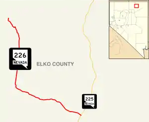
State Route 226 (SR 226) is a state highway in Elko County, Nevada, United States. It spurs off State Route 225 north of Elko, and heads north for 39 miles (63 km) to Deep Creek.
_in_Elko_County%252C_Nevada.JPG.webp)
View from the north end of SR 226 looking southbound
History
SR 226 was part of the State Route 11 before 1976
SR 226 was part of a much-longer State Route 11 prior to 1976.
Major intersections
The entire route is in Elko County.
| Location | mi | km | Destinations | Notes | |
|---|---|---|---|---|---|
| | 0 | 0.0 | |||
| | Old SR 18 – Tuscarora | ||||
| Deep Creek | 31 | 50 | |||
| 1.000 mi = 1.609 km; 1.000 km = 0.621 mi | |||||
See also
References
Template:Attached KML/Nevada State Route 226
KML is not from Wikidata
- ↑ Nevada Department of Transportation (January 2017). "State Maintained Highways of Nevada: Descriptions and Maps". Retrieved 2017-04-28.
Wikimedia Commons has media related to Nevada State Route 226.
This article is issued from Wikipedia. The text is licensed under Creative Commons - Attribution - Sharealike. Additional terms may apply for the media files.