Niederer Fläming | |
|---|---|
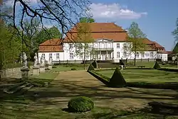 Wiepersdorf manor | |
Location of Niederer Fläming within Teltow-Fläming district 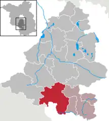 | |
 Niederer Fläming  Niederer Fläming | |
| Coordinates: 51°54′N 13°12′E / 51.900°N 13.200°E | |
| Country | Germany |
| State | Brandenburg |
| District | Teltow-Fläming |
| Municipal assoc. | Dahme/Mark |
| Subdivisions | 23 Ortsteile |
| Government | |
| • Mayor (2019–24) | Matthias Wäsche[1] |
| Area | |
| • Total | 185.36 km2 (71.57 sq mi) |
| Highest elevation | 132 m (433 ft) |
| Lowest elevation | 80 m (260 ft) |
| Population (2021-12-31)[2] | |
| • Total | 3,037 |
| • Density | 16/km2 (42/sq mi) |
| Time zone | UTC+01:00 (CET) |
| • Summer (DST) | UTC+02:00 (CEST) |
| Postal codes | 14913 |
| Dialling codes | 033746 |
| Vehicle registration | TF |
| Website | www.gemeinde-niederer-flaeming.de |
Niederer Fläming is a municipality in the Teltow-Fläming district of Brandenburg, Germany.
Demography
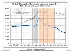 Development of Population since 1875 within the Current Boundaries (Blue Line: Population; Dotted Line: Comparison to Population Development of Brandenburg state; Grey Background: Time of Nazi rule; Red Background: Time of Communist rule)
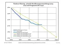 Recent Population Development and Projections (Population Development before Census 2011 (blue line); Recent Population Development according to the Census in Germany in 2011 (blue bordered line); Projection by the Brandenburg state for 2005-2030 (yellow line); Projection by the Brandenburg state for 2014-2030 (red line)
|
|
|
References
- ↑ Landkreis Teltow-Fläming Wahl der Bürgermeisterin / des Bürgermeisters, accessed 4 July 2021.
- ↑ "Bevölkerungsentwicklung und Flächen der kreisfreien Städte, Landkreise und Gemeinden im Land Brandenburg 2021" (PDF). Amt für Statistik Berlin-Brandenburg (in German). June 2022.
- ↑ Detailed data sources are to be found in the Wikimedia Commons.Population Projection Brandenburg at Wikimedia Commons
Towns and municipalities in Teltow-Fläming | ||
|---|---|---|
Coat of arms of Teltow-Fläming district | ||
This article is issued from Wikipedia. The text is licensed under Creative Commons - Attribution - Sharealike. Additional terms may apply for the media files.