Norwood, Kansas | |
|---|---|
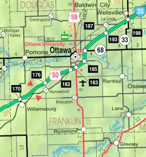 KDOT map of Franklin County (legend) | |
 Norwood  Norwood | |
| Coordinates: 38°42′35″N 95°14′49″W / 38.70972°N 95.24694°W[1] | |
| Country | United States |
| State | Kansas |
| County | Franklin |
| Elevation | 948 ft (289 m) |
| Population | |
| • Total | 0 |
| Time zone | UTC-6 (CST) |
| • Summer (DST) | UTC-5 (CDT) |
| FIPS code | 20-51610 [1] |
| GNIS ID | 484888 [1] |
Norwood is a ghost town in north Franklin County, Kansas, United States.[1] It is located approximately 1.25 miles (2.01 km) east of U.S. Route 59 on Stafford Rd, and 2 miles (3.2 km) south of the Franklin-Douglas county line.[1]
History
The town was named after Henry Ward Beecher's novel Norwood: or, Village Life in New England.[2] A post office was established at Norwood in 1868 which closed and reopened a few times until it closed permanently in 1914.[3]
Today, the city is considered a ghost town, serving only as a stop on the recreational Midland Railway. The town now consists of one house, one train depot, and public restroom facilities.[4][5]
References
- 1 2 3 4 5 6 "Norwood, Kansas", Geographic Names Information System, United States Geological Survey, United States Department of the Interior
- ↑ "Profile for Norwood, Kansas". ePodunk. Retrieved June 10, 2014.
- ↑ "Kansas Post Offices, 1828-1961 (archived)". Kansas Historical Society. Archived from the original on October 9, 2013. Retrieved June 10, 2014.
- ↑ "Norwood". www.ghosttowns.com.
- ↑ "Midland Railway Historical Association". Midland Railway Historical Association.
Further reading
External links
Municipalities and communities of Franklin County, Kansas, United States | ||
|---|---|---|
| Cities | 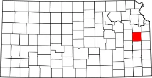 Map of Kansas highlighting Franklin County | |
| Unincorporated communities | ||
| Ghost towns | ||
| Townships | ||
| Footnotes | †This community is designated a Census-Designated Place (CDP) by the United States Census Bureau. | |
This article is issued from Wikipedia. The text is licensed under Creative Commons - Attribution - Sharealike. Additional terms may apply for the media files.