Ols-et-Rinhodes | |
|---|---|
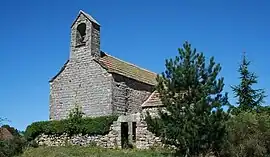 The church in Rinhodes | |
Location of Ols-et-Rinhodes | |
 Ols-et-Rinhodes  Ols-et-Rinhodes | |
| Coordinates: 44°28′02″N 1°57′42″E / 44.4672°N 1.9617°E | |
| Country | France |
| Region | Occitania |
| Department | Aveyron |
| Arrondissement | Villefranche-de-Rouergue |
| Canton | Villeneuvois et Villefranchois |
| Government | |
| • Mayor (2020–2026) | Christian Saint-Affre[1] |
| Area 1 | 10.82 km2 (4.18 sq mi) |
| Population | 179 |
| • Density | 17/km2 (43/sq mi) |
| Time zone | UTC+01:00 (CET) |
| • Summer (DST) | UTC+02:00 (CEST) |
| INSEE/Postal code | 12175 /12260 |
| Elevation | 305–400 m (1,001–1,312 ft) (avg. 328 m or 1,076 ft) |
| 1 French Land Register data, which excludes lakes, ponds, glaciers > 1 km2 (0.386 sq mi or 247 acres) and river estuaries. | |
Ols-et-Rinhodes is a commune in the Aveyron department in southern France.
Population
| Year | Pop. | ±% |
|---|---|---|
| 1962 | 113 | — |
| 1968 | 115 | +1.8% |
| 1975 | 122 | +6.1% |
| 1982 | 128 | +4.9% |
| 1990 | 137 | +7.0% |
| 1999 | 120 | −12.4% |
| 2008 | 145 | +20.8% |
See also
References
- ↑ "Répertoire national des élus: les maires". data.gouv.fr, Plateforme ouverte des données publiques françaises (in French). 2 December 2020.
- ↑ "Populations légales 2021". The National Institute of Statistics and Economic Studies. 28 December 2023.
Wikimedia Commons has media related to Ols-et-Rinhodes.
This article is issued from Wikipedia. The text is licensed under Creative Commons - Attribution - Sharealike. Additional terms may apply for the media files.