Omonville-la-Rogue | |
|---|---|
Part of La Hague | |
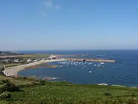 Port du Hâble, seen from the fort | |
Location of Omonville-la-Rogue | |
 Omonville-la-Rogue  Omonville-la-Rogue | |
| Coordinates: 49°42′12″N 1°50′32″W / 49.7033°N 1.8422°W | |
| Country | France |
| Region | Normandy |
| Department | Manche |
| Arrondissement | Cherbourg |
| Canton | La Hague |
| Commune | La Hague |
| Area 1 | 4.29 km2 (1.66 sq mi) |
| Population (2019)[1] | 444 |
| • Density | 100/km2 (270/sq mi) |
| Demonym | Omonvillais |
| Time zone | UTC+01:00 (CET) |
| • Summer (DST) | UTC+02:00 (CEST) |
| Postal code | 50440 |
| Elevation | 0–133 m (0–436 ft) (avg. 20 m or 66 ft) |
| 1 French Land Register data, which excludes lakes, ponds, glaciers > 1 km2 (0.386 sq mi or 247 acres) and river estuaries. | |
Omonville-la-Rogue (French pronunciation: [ɔmɔ̃vil la ʁɔɡ]) is a former commune in the Manche department in Normandy in north-western France. On 1 January 2017, it was merged into the new commune La Hague.[2] It is the site of one of the few ports on this rugged coastline.
See also
References
- ↑ Téléchargement du fichier d'ensemble des populations légales en 2019, INSEE
- ↑ Arrêté préfectoral 27 September 2016 (in French)
Wikimedia Commons has media related to Omonville-la-Rogue.
This article is issued from Wikipedia. The text is licensed under Creative Commons - Attribution - Sharealike. Additional terms may apply for the media files.