Pak Nhai
ប៉ក់ញ៉ៃ | |
|---|---|
 Pak Nhai Location within Cambodia | |
| Coordinates: 13°42′05″N 107°30′02″E / 13.7013°N 107.5005°E | |
| Country | |
| Province | Ratanakiri Province |
| District | Ou Ya Dav District |
| Villages | 4 |
| Population (1998) | |
| • Total | 2,156 |
| Time zone | UTC+07 |
| Geocode | 160703 |
Pak Nhai (Khmer: ប៉ក់ញ៉ៃ) is a commune in Ou Ya Dav District in northeast Cambodia. It contains four villages and has a population of 2,156.[1] In the 2007 commune council elections, three of the commune's five seats went to the Cambodian People's Party and two went to the Sam Rainsy Party.[2] The land alienation rate in Pak Nhai was severe as of January 2006.[3] (See Ratanakiri Province for background information on land alienation.)
| Village[1][4] | Population[1] (1998) | Sex ratio[1] (male/female) (1998) | Number of households[1] (1998) | Notes |
|---|---|---|---|---|
| Pak Thum | 956 | 1.14 | 162 | |
| Pak Touch | 228 | 1.11 | 45 | |
| Pak Por | 311 | 0.94 | 51 | |
| Lom | 661 | 1.02 | 119 |
References
- 1 2 3 4 5 "Final Population Totals, Rotanak Kiri Province, 1998" Archived 2008-10-29 at the Wayback Machine. Cambodia National Institute of Statistics. Accessed June 6, 2008.
- ↑ "Official Results of the 2007 Commune Councils Election in Ratank Kiri" Archived 2008-06-02 at the Wayback Machine. [sic] National Election Committee, No 4.58/07 NEC.SG.PIB (April 18, 2007). Accessed June 6, 2008.
- ↑ "Land Alienation in Indigenous Minority Communities - Ratanakiri Province, Cambodia" Archived 2008-06-14 at the Wayback Machine. NGO Forum on Cambodia (August 2006). Accessed June 6, 2008.
- ↑ "Ratanak Kiri Province" Archived 2008-06-02 at the Wayback Machine. Cambodia National Institute of Statistics. Accessed June 6, 2008.
Capital city: Banlung | |||||||||||||||||||
| Landmarks | 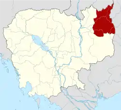 | ||||||||||||||||||
| Administrative divisions |
| ||||||||||||||||||
This article is issued from Wikipedia. The text is licensed under Creative Commons - Attribution - Sharealike. Additional terms may apply for the media files.