Paraisópolis | |
|---|---|
 Flag  Coat of arms | |
| Nickname: Paraiso | |
 | |
 Paraisópolis | |
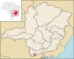
| Coordinates: 22°33′14″S 45°46′48″W / 22.55389°S 45.78000°W | |
| Country | Brazil |
| State | Minas Gerais |
| Mesoregion | Sul/Sudoeste de Minas (IBGE/2008)[1] |
| Microregion | Itajubá (IBGE/2008)[1] |
| Government | |
| • Mayor | Sérgio Wagner Bizarria (until 2012) |
| Area | |
| • Total | 331,510 km2 (128,000 sq mi) |
| Elevation | 968 m (3,176 ft) |
| Population (2020 [3]) | |
| • Total | 21,221 |
| Demonym | paraisopolitano or paraisopolense |
Paraisópolis is a city in Minas Gerais, Brazil, with a population (2020) of 21,221.
The municipality contains part of the 180,373 hectares (445,710 acres) Fernão Dias Environmental Protection Area, created in 1997.[4]
References
- 1 2 "Divisão Territorial do Brasil". Divisão Territorial do Brasil e Limites Territoriais. Instituto Brasileiro de Geografia e Estatística (IBGE). 1 July 2008. Retrieved 11 October 2008.
- ↑ IBGE (2002). "Área territorial oficial". Resolução da Presidência do IBGE de n° 5 (R.PR-5/02). Retrieved 5 December 2010.
- ↑ IBGE 2020
- ↑ APA Fernão Dias (in Portuguese), ISA: Instituto Socioambiental, retrieved 2 October 2016
This article is issued from Wikipedia. The text is licensed under Creative Commons - Attribution - Sharealike. Additional terms may apply for the media files.