Patterson, North Carolina | |
|---|---|
 Patterson  Patterson | |
| Coordinates: 35°59′57″N 81°33′50″W / 35.99917°N 81.56389°W | |
| Country | United States |
| State | North Carolina |
| County | Caldwell |
| Elevation | 1,257 ft (383 m) |
| Time zone | UTC-5 (Eastern (EST)) |
| • Summer (DST) | UTC-4 (EDT) |
| ZIP code | 28661 |
| Area code | 828 |
| GNIS feature ID | 1014252[1] |
Patterson is an unincorporated community in Caldwell County, North Carolina, United States. Patterson is located near U.S. Route 321, 6 miles (9.7 km) north-northwest of Lenoir. Patterson has a post office with ZIP code 28661.[2]
Clover Hill was listed on the National Register of Historic Places in 1973.[3]
References
Municipalities and communities of Caldwell County, North Carolina, United States | ||
|---|---|---|
| Cities | 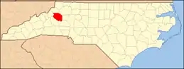 Caldwell County map | |
| Towns | ||
| Village | ||
| CDP | ||
| Unincorporated communities | ||
| Footnotes | ‡This populated place also has portions in an adjacent county or counties | |
This article is issued from Wikipedia. The text is licensed under Creative Commons - Attribution - Sharealike. Additional terms may apply for the media files.