Penfield, Pennsylvania | |
|---|---|
Unincorporated community | |
 | |
 Penfield | |
| Coordinates: 41°12′30″N 78°34′32″W / 41.20833°N 78.57556°W | |
| Country | United States |
| State | Pennsylvania |
| County | Clearfield |
| Elevation | 1,237 ft (377 m) |
| Time zone | UTC-5 (Eastern (EST)) |
| • Summer (DST) | UTC-4 (EDT) |
| ZIP code | 15849 |
| Area code | 814 |
| GNIS feature ID | 1183465[1] |
Penfield is an unincorporated community that is located in Clearfield County, Pennsylvania, United States.[1]
Geography and notable features
The community is situated at the intersection of Pennsylvania Route 153 and Pennsylvania Route 255, 11.3 miles (18.2 km) east-northeast of DuBois.
Penfield has a post office with ZIP code 15849.[2][3]
Gallery
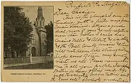 Presbyterian church, 1907 postcard
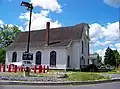 Former Presbyterian church, 2007
References
- 1 2 "Penfield". Geographic Names Information System. United States Geological Survey, United States Department of the Interior.
- ↑ United States Postal Service. "USPS - Look Up a ZIP Code". Retrieved April 5, 2015.
- ↑ "Postmaster Finder - Post Offices by ZIP Code". United States Postal Service. Retrieved April 5, 2015.
Municipalities and communities of Clearfield County, Pennsylvania, United States | ||
|---|---|---|
| City | ||
| Boroughs | ||
| Townships | ||
| CDPs | ||
| Unincorporated communities |
| |
| Footnotes | ‡This populated place also has portions in an adjacent county or counties | |
This article is issued from Wikipedia. The text is licensed under Creative Commons - Attribution - Sharealike. Additional terms may apply for the media files.