18th District of Budapest
Budapest XVIII. kerülete Pestszentlőrinc‑Pestszentimre | |
|---|---|
| District XVIII | |
 Flag  Coat of arms | |
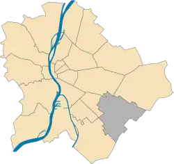 Location of District XVIII in Budapest (shown in grey) | |
| Coordinates: 47°26′N 19°12′E / 47.433°N 19.200°E | |
| Country | Hungary |
| Region | Central Hungary |
| City | Budapest |
| Established | 1 January 1950 |
| Quarters[1] | List
|
| Government | |
| • Mayor | Sándor Szaniszló (DK) |
| Area | |
| • Total | 38.60 km2 (14.90 sq mi) |
| • Rank | 4th |
| Population (2016)[2] | |
| • Total | 101,738 |
| • Rank | 5th |
| • Density | 2,635/km2 (6,820/sq mi) |
| Demonym | tizennyolcadik kerületi ("18th districter") |
| Time zone | UTC+1 (CET) |
| • Summer (DST) | UTC+2 (CEST) |
| Postal code | 1181 ... 1188 |
| Website | www |
Pestszentlőrinc‑Pestszentimre (also known as Budapest XVIII. kerülete; German: Sankt Lorenz-Sankt Emmerich) is the 18th district of Budapest is situated at the south-eastern part of the city. It is made up of two earlier distinct towns: Pestszentlőrinc and Pestszentimre.
The population of the district today is around 100.000 and this amount is divided between the two divisions as 80%-20%. The area joined Budapest shortly after World War II (see Great-Budapest).
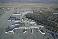
Budapest's international airport (Ferihegy Airport), the Hungarian Meteorological Service and the Central Atmospheric Institute are located here.
List of mayors
| Member | Party | Date | |
|---|---|---|---|
| Endre Molich | SZDSZ | 1990–1994 | |
| László Mester | MSZP | 1994–2010 | |
| Attila Ughy | Fidesz | 2010–2019 | |
| Sándor Szaniszló | DK | 2019– | |
Twin towns - twin cities
Pestszentlőrinc-Pestszentimre is twinned with:
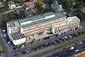
Gallery
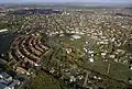

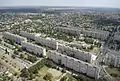
civertanlegi.jpg.webp)

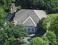
civertanlegi.jpg.webp)
References
- ↑ "94/2012. (XII. 27.) Főv. Kgy. rendelet - a közterület- és városrésznevek megállapításáról, azok jelöléséről, valamint a házszám-megállapítás szabályairól" (in Hungarian).
- 1 2 "A fővárosi kerületek, a megyei jogú városok, a városok területe, lakónépessége és a lakások száma" [The area of districts of the capital, of the towns with county's rights, resident population and number of dwellings]. Magyarország közigazgatási helynévkönyve 2016. január 1 [Gazetteer of Hungary 1st January, 2016] (PDF). Hungarian Central Statistical Office. 2016. p. 21.
External links
- Official site (Hungarian)
- Aerial photographs of Pestszentlőrinc
|  | |
This article is issued from Wikipedia. The text is licensed under Creative Commons - Attribution - Sharealike. Additional terms may apply for the media files.