| Petite Sauldre | |
|---|---|
 | |
  | |
| Physical characteristics | |
| Source | |
| • location | near Parassy |
| • coordinates | 47°14′10″N 2°33′00″E / 47.236°N 2.550°E |
| • elevation | 310 m (1,020 ft) |
| Mouth | |
• location | Sauldre, northeast of Salbris |
• coordinates | 47°27′04″N 2°04′53″E / 47.451°N 2.0814°E |
• elevation | 109 m (358 ft) |
| Basin features | |
| Progression | Sauldre→ Cher→ Loire→ Atlantic Ocean |
| Tributaries | |
| • right | Vernon |
| Source | Sandre, Géoportail |
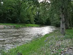
The Petite Sauldre is a 63.3-kilometre (39.3 mi) long river of France.[1] Near Salbris, it joins with the Grande Sauldre, to form the Sauldre.[2]
Communes
The river passes through the following communes.
- Cher
- Parassy, Henrichemont, Menetou-Salon, Achères, Ivoy-le-Pré, La Chapelle-d'Angillon, Ennordres, Ménétréol-sur-Sauldre
- Loir-et-Cher
References
Wikimedia Commons has media related to Petite Sauldre.
- ↑ Sandre. "Fiche cours d'eau (K63-0300)".
- ↑ Baynes, Thomas Spencer (1833). The Encyclopædia Britannica: a dictionary of arts, sciences, and general literature. Vol. 5. C. Scribner's sons. p. 584.
This article is issued from Wikipedia. The text is licensed under Creative Commons - Attribution - Sharealike. Additional terms may apply for the media files.