Pfarrkirchen bei Bad Hall | |
|---|---|
 | |
 Coat of arms | |
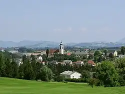
 Pfarrkirchen bei Bad Hall Location within Austria | |
| Coordinates: 48°01′49″N 14°11′58″E / 48.03028°N 14.19944°E | |
| Country | Austria |
| State | Upper Austria |
| District | Steyr-Land |
| Government | |
| • Mayor | Daniela Chimani (SPÖ) |
| Area | |
| • Total | 11.18 km2 (4.32 sq mi) |
| Elevation | 397 m (1,302 ft) |
| Population (2018-01-01)[2] | |
| • Total | 2,244 |
| • Density | 200/km2 (520/sq mi) |
| Time zone | UTC+1 (CET) |
| • Summer (DST) | UTC+2 (CEST) |
| Postal code | 4540 |
| Area code | 07258 |
| Vehicle registration | SE |
| Website | www.pfarrkirchen-badhall.at |
Pfarrkirchen bei Bad Hall is a municipality in the district of Steyr-Land in the Austrian state of Upper Austria.
Geography
Pfarrkirchen lies in the Traunviertel. About 10 percent of the municipality is forest, and 77 percent is farmland.
References
- ↑ "Dauersiedlungsraum der Gemeinden Politischen Bezirke und Bundesländer - Gebietsstand 1.1.2018". Statistics Austria. Retrieved 10 March 2019.
- ↑ "Einwohnerzahl 1.1.2018 nach Gemeinden mit Status, Gebietsstand 1.1.2018". Statistics Austria. Retrieved 9 March 2019.
Wikimedia Commons has media related to Pfarrkirchen bei Bad Hall.
This article is issued from Wikipedia. The text is licensed under Creative Commons - Attribution - Sharealike. Additional terms may apply for the media files.