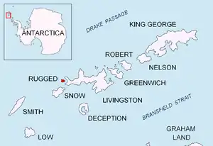
 Location of Rugged Island in the South Shetland Islands | |
 Pindarev Island Location of Pindarev Island  Pindarev Island Pindarev Island (South Shetland Islands) | |
| Geography | |
|---|---|
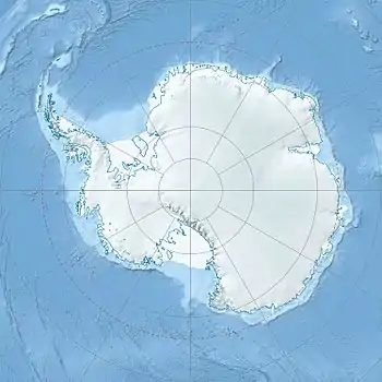
| Location | Antarctica |
| Coordinates | 62°36′57.6″S 61°17′07″W / 62.616000°S 61.28528°W |
| Archipelago | South Shetland Islands |
| Area | 1.9 ha (4.7 acres) |
| Length | 250 m (820 ft) |
| Width | 115 m (377 ft) |
| Administration | |
| Administered under the Antarctic Treaty System | |
| Demographics | |
| Population | uninhabited |
Pindarev Island (Bulgarian: Пиндарев остров, romanized: Pindarev ostrov, IPA: [pinˈdarɛf ˈɔstrof]) is the 250 m long in southeast-northwest direction and 115 m wide flat rocky island in Nishava Cove separated from the north coast of Rugged Island in the South Shetland Islands by a 35 m wide passage. Its surface area is 1.9 ha.[1] The area was visited by early 19th century sealers.[2]
The feature is named after the Bulgarian cartoonist Tenyu Pindarev (1921–2010), for his contribution to the promotion of Antarctica.[1]
Location
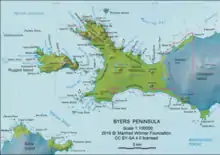
Pindarev Island is located at 62°36′57.6″S 61°17′07″W / 62.616000°S 61.28528°W, which is 590 m east-southeast of Cape Sheffield and 950 m west of Chiprovtsi Point. Detailed Spanish mapping in 1992, and Bulgarian mapping in 2009 and 2017.
Maps
- Península Byers, Isla Livingston. Mapa topográfico a escala 1:25000. Madrid: Servicio Geográfico del Ejército, 1992
- L. Ivanov. Antarctica: Livingston Island and Greenwich, Robert, Snow and Smith Islands. Scale 1:120000 topographic map. Troyan: Manfred Wörner Foundation, 2010. ISBN 978-954-92032-9-5 (First edition 2009. ISBN 978-954-92032-6-4)
- L. Ivanov. Antarctica: Livingston Island and Smith Island. Scale 1:100000 topographic map. Manfred Wörner Foundation, 2017. ISBN 978-619-90008-3-0
- Antarctic Digital Database (ADD). Scale 1:250000 topographic map of Antarctica. Scientific Committee on Antarctic Research (SCAR). Since 1993, regularly upgraded and updated
See also
Notes
- 1 2 Pindarev Island. SCAR Composite Gazetteer of Antarctica
- ↑ L. Ivanov. General Geography and History of Livingston Island. In: Bulgarian Antarctic Research: A Synthesis. Eds. C. Pimpirev and N. Chipev. Sofia: St. Kliment Ohridski University Press, 2015. pp. 17–28.
References
- Pindarev Island. SCAR Composite Gazetteer of Antarctica
- Bulgarian Antarctic Gazetteer. Antarctic Place-names Commission. (details in Bulgarian, basic data in English)
External links
- Pindarev Island. Adjusted Copernix satellite image
This article includes information from the Antarctic Place-names Commission of Bulgaria which is used with permission.