Pleasant Ridge, Wisconsin | |
|---|---|
 Pleasant Ridge  Pleasant Ridge | |
| Coordinates: 43°03′17″N 90°04′24″W / 43.05472°N 90.07333°W | |
| Country | |
| State | |
| County | Iowa |
| Town | Dodgeville |
| Elevation | 380 m (1,247 ft) |
| Time zone | UTC-6 (Central (CST)) |
| • Summer (DST) | UTC-5 (CDT) |
| Area code | 608 |
| GNIS feature ID | 1577773[1] |
Pleasant Ridge is an unincorporated community located in the town of Dodgeville, Iowa County, Wisconsin, United States. Pleasant Ridge is located at the intersection of County Highways Z and ZZ 7 miles (11 km) north-northeast of the city of Dodgeville.[2]
References
- ↑ U.S. Geological Survey Geographic Names Information System: Pleasant Ridge, Wisconsin
- ↑ Iowa County (PDF) (Map). Wisconsin Department of Transportation. 2011. Archived from the original (PDF) on January 30, 2012. Retrieved October 9, 2011.
Further reading
- Stark, William F. (1977). "Pleasant Ridge". Ghost Towns of Wisconsin. Sheboygan: Zimmermann Press. pp. 59–69. OCLC 3564408.
Municipalities and communities of Iowa County, Wisconsin, United States | ||
|---|---|---|
| Cities | 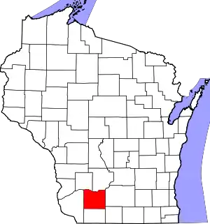 | |
| Villages | ||
| Towns | ||
| CDP | ||
| Unincorporated communities | ||
| Ghost towns | ||
| Footnotes | ‡This populated place also has portions in an adjacent county or counties | |
This article is issued from Wikipedia. The text is licensed under Creative Commons - Attribution - Sharealike. Additional terms may apply for the media files.