Plumtree | |
|---|---|
 Plumtree Location within the state of North Carolina | |
| Coordinates: 36°01′37″N 82°00′28″W / 36.02694°N 82.00778°W | |
| Country | United States |
| State | North Carolina |
| County | Avery County |
| Named for | Plumtree Creek[1] |
| Elevation | 2,867 ft (874 m) |
| Time zone | UTC-5 (Eastern (EST)) |
| • Summer (DST) | UTC-4 (EDT) |
| ZIP code | 28664 |
| Area code | 828 |
| GNIS feature ID | 1022015[2] |
Plumtree is an unincorporated community in Avery County, North Carolina, United States. The community is located along US 19-E, between the communities of Roaring Creek and Ingalls.
See also
References
- ↑ "North Carolina Gazetteer". Retrieved December 23, 2020.
- ↑ U.S. Geological Survey Geographic Names Information System: Plumtree, North Carolina
Municipalities and communities of Avery County, North Carolina, United States | ||
|---|---|---|
| Towns | 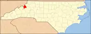 | |
| Villages | ||
| CDP | ||
| Other communities | ||
| Footnotes | ‡This populated place also has portions in an adjacent county or counties | |
This article is issued from Wikipedia. The text is licensed under Creative Commons - Attribution - Sharealike. Additional terms may apply for the media files.