Polepy | |
|---|---|
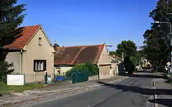 Main street | |
 Flag _znak.jpg.webp) Coat of arms | |
 Polepy Location in the Czech Republic | |
| Coordinates: 50°0′17″N 15°12′22″E / 50.00472°N 15.20611°E | |
| Country | |
| Region | Central Bohemian |
| District | Kolín |
| First mentioned | 1343 |
| Area | |
| • Total | 2.42 km2 (0.93 sq mi) |
| Elevation | 212 m (696 ft) |
| Population (2023-01-01)[1] | |
| • Total | 651 |
| • Density | 270/km2 (700/sq mi) |
| Time zone | UTC+1 (CET) |
| • Summer (DST) | UTC+2 (CEST) |
| Postal code | 280 02 |
| Website | www |
Polepy is a municipality and village in Kolín District in the Central Bohemian Region of the Czech Republic. It has about 700 inhabitants.
Gallery
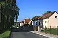 Middle part
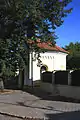 Small chapel
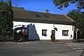 Restaurant
References
Wikimedia Commons has media related to Polepy (Kolín District).
This article is issued from Wikipedia. The text is licensed under Creative Commons - Attribution - Sharealike. Additional terms may apply for the media files.