Portbail | |
|---|---|
Part of Port-Bail-sur-Mer | |
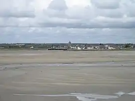 View of Portbail | |
.svg.png.webp) Coat of arms | |
Location of Portbail | |
 Portbail  Portbail | |
| Coordinates: 49°20′10″N 1°41′41″W / 49.3361°N 1.6947°W | |
| Country | France |
| Region | Normandy |
| Department | Manche |
| Arrondissement | Cherbourg |
| Canton | Les Pieux |
| Commune | Port-Bail-sur-Mer |
| Area 1 | 19.56 km2 (7.55 sq mi) |
| Population (2019)[1] | 1,491 |
| • Density | 76/km2 (200/sq mi) |
| Demonym | Portbaillais |
| Time zone | UTC+01:00 (CET) |
| • Summer (DST) | UTC+02:00 (CEST) |
| Postal code | 50580 |
| Elevation | 2–90 m (6.6–295.3 ft) (avg. 10 m or 33 ft) |
| Website | www.portbail.fr |
| 1 French Land Register data, which excludes lakes, ponds, glaciers > 1 km2 (0.386 sq mi or 247 acres) and river estuaries. | |
Portbail (French pronunciation: [pɔʁbaj]; sometimes spelled Port-Bail) is a former commune in the Manche department in north-western France. On 1 January 2019, it was merged into the new commune Port-Bail-sur-Mer.[2]
Heraldry
.JPG.webp)
« Thirteen arches bridge»
The arms of Portbail are blazoned :
Azure, a chevron abased, between in fess 3 mullets Or and a lancehead argent.
Demography
| Year | Pop. | ±% |
|---|---|---|
| 1962 | 1,431 | — |
| 1968 | 1,499 | +4.8% |
| 1975 | 1,591 | +6.1% |
| 1982 | 1,707 | +7.3% |
| 1990 | 1,654 | −3.1% |
| 1999 | 1,675 | +1.3% |
| 2019 | 1,491 | −11.0% |
| Source: EHESS[3] and INSEE[1] | ||
See also
References
- 1 2 Téléchargement du fichier d'ensemble des populations légales en 2019, INSEE
- ↑ Arrêté préfectoral 20 December 2018, p. 3 (in French)
- ↑ Des villages de Cassini aux communes d'aujourd'hui: Commune data sheet Portbail, EHESS (in French).
Wikimedia Commons has media related to Portbail.
This article is issued from Wikipedia. The text is licensed under Creative Commons - Attribution - Sharealike. Additional terms may apply for the media files.