Portengen | |
|---|---|
Hamlet | |
 | |
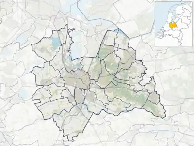 Portengen Location in the Netherlands  Portengen Portengen (Netherlands) | |
| Coordinates: 52°09′21″N 4°57′48″E / 52.15583°N 4.96333°E | |
| Country | Netherlands |
| Province | Utrecht |
| Municipality | Stichtse Vecht |
| Area | |
| • Total | 6.87 km2 (2.65 sq mi) |
| Elevation | −0.5 m (−1.6 ft) |
| Population (2021)[1] | |
| • Total | 285 |
| • Density | 41/km2 (110/sq mi) |
| Time zone | UTC+1 (CET) |
| • Summer (DST) | UTC+2 (CEST) |
| Postal code | 3628[1] |
| Dialing code | 0346 |
Portengen is a hamlet in the Dutch province of Utrecht. It is located in the municipality of Stichtse Vecht, 1 km (0.62 mi) northeast of Kockengen.
Portengen was a separate municipality from 1818 to 1857, when it was merged with Breukelen-Nijenrode.[3]
The hamlet was first mentioned in 1217 as Britannien, and is a reference to Brittany, France. It started as a peat excavation colony during the 11th and 12th century.[4] The hamlet of Portengensebrug is an enclave within Portengen. In 1840, Portengen was home to 55 people.[5]
Gallery
 View on Portengensebrug
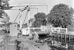
 Pumping station Dooijersluis
 Farm in Portegen
References
- 1 2 3 "Kerncijfers wijken en buurten 2021". Central Bureau of Statistics. Retrieved 27 March 2022.
- ↑ "Postcodetool for 3628AA". Actueel Hoogtebestand Nederland (in Dutch). Het Waterschapshuis. Retrieved 27 March 2022.
- ↑ Ad van der Meer and Onno Boonstra, Repertorium van Nederlandse gemeenten, KNAW, 2011.
- ↑ "Portengen - (geografische naam)". Etymologiebank (in Dutch). Retrieved 27 March 2022.
- ↑ "Portengen". Plaatsengids (in Dutch). Retrieved 27 March 2022.
Wikimedia Commons has media related to Portengen.
This article is issued from Wikipedia. The text is licensed under Creative Commons - Attribution - Sharealike. Additional terms may apply for the media files.