Posey Township | |
|---|---|
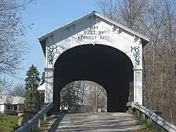 The Offutt Covered Bridge, a historic site in the township | |
 | |
| Coordinates: 39°39′18″N 85°34′17″W / 39.65500°N 85.57139°W | |
| Country | United States |
| State | Indiana |
| County | Rush |
| Government | |
| • Type | Indiana township |
| Area | |
| • Total | 36.27 sq mi (93.9 km2) |
| • Land | 36.25 sq mi (93.9 km2) |
| • Water | 0.02 sq mi (0.05 km2) |
| Elevation | 925 ft (282 m) |
| Population (2010) | |
| • Total | 1,083 |
| • Density | 29.9/sq mi (11.5/km2) |
| Time zone | UTC-5 (Eastern (EST)) |
| • Summer (DST) | UTC-4 (EDT) |
| Area code | 765 |
| FIPS code | 18-61362[2] |
| GNIS feature ID | 453765 |
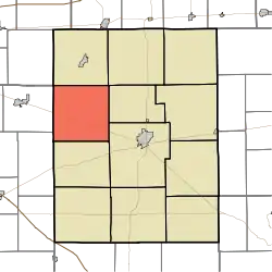
Posey Township is one of twelve townships in Rush County, Indiana. As of the 2010 census, its population was 1,083 and it contained 455 housing units.[3]
History
The Offutt Covered Bridge was listed on the National Register of Historic Places in 1983.[4]
Geography
According to the 2010 census, the township has a total area of 36.27 square miles (93.9 km2), of which 36.25 square miles (93.9 km2) (or 99.94%) is land and 0.02 square miles (0.052 km2) (or 0.06%) is water.[3]
Unincorporated towns
(This list is based on USGS data and may include former settlements.)
References
- ↑ "US Board on Geographic Names". United States Geological Survey. October 25, 2007. Retrieved January 31, 2008.
- ↑ "U.S. Census website". United States Census Bureau. Retrieved January 31, 2008.
- 1 2 "Population, Housing Units, Area, and Density: 2010 - County -- County Subdivision and Place -- 2010 Census Summary File 1". United States Census. Archived from the original on February 12, 2020. Retrieved May 10, 2013.
- ↑ "National Register Information System". National Register of Historic Places. National Park Service. July 9, 2010.
External links
Municipalities and communities of Rush County, Indiana, United States | ||
|---|---|---|
| City | Map of Indiana highlighting Rush County | |
| Towns | ||
| Townships | ||
| CDPs | ||
| Other communities | ||
| Footnotes | ‡This populated place also has portions in an adjacent county or counties | |
This article is issued from Wikipedia. The text is licensed under Creative Commons - Attribution - Sharealike. Additional terms may apply for the media files.