Prugnanes
Prunyanes Prunhanas | |
|---|---|
 | |
Location of Prugnanes | |
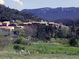
 Prugnanes  Prugnanes | |
| Coordinates: 42°49′32″N 2°26′02″E / 42.8256°N 2.4339°E | |
| Country | France |
| Region | Occitania |
| Department | Pyrénées-Orientales |
| Arrondissement | Prades |
| Canton | La Vallée de l'Agly |
| Intercommunality | Agly Fenouillèdes |
| Government | |
| • Mayor (2020–2026) | Pierre-Henri Bintein[1] |
| Area 1 | 13.51 km2 (5.22 sq mi) |
| Population | 105 |
| • Density | 7.8/km2 (20/sq mi) |
| Time zone | UTC+01:00 (CET) |
| • Summer (DST) | UTC+02:00 (CEST) |
| INSEE/Postal code | 66152 /66220 |
| Elevation | 272–909 m (892–2,982 ft) (avg. 403 m or 1,322 ft) |
| 1 French Land Register data, which excludes lakes, ponds, glaciers > 1 km2 (0.386 sq mi or 247 acres) and river estuaries. | |
Prugnanes (French pronunciation: [pʁyɲan] ⓘ; Occitan: Prunhanas; Catalan: Prunyanes) is a commune in the Pyrénées-Orientales department in southern France.
Geography
Prugnanes is in the canton of La Vallée de l'Agly and in the arrondissement of Perpignan.
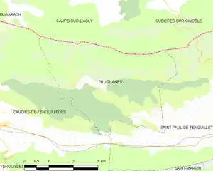
Map of Prugnanes and its surrounding communes
Population
| Year | Pop. | ±% p.a. |
|---|---|---|
| 1968 | 85 | — |
| 1975 | 79 | −1.04% |
| 1982 | 65 | −2.75% |
| 1990 | 55 | −2.07% |
| 1999 | 69 | +2.55% |
| 2007 | 100 | +4.75% |
| 2012 | 102 | +0.40% |
| 2017 | 104 | +0.39% |
| Source: INSEE[3] | ||
See also
References
- ↑ "Répertoire national des élus: les maires". data.gouv.fr, Plateforme ouverte des données publiques françaises (in French). 2 December 2020.
- ↑ "Populations légales 2021". The National Institute of Statistics and Economic Studies. 28 December 2023.
- ↑ Population en historique depuis 1968, INSEE
Wikimedia Commons has media related to Prugnanes.
This article is issued from Wikipedia. The text is licensed under Creative Commons - Attribution - Sharealike. Additional terms may apply for the media files.