Pryorsburg, Kentucky | |
|---|---|
 Pryorsburg  Pryorsburg | |
| Coordinates: 36°41′20″N 88°42′53″W / 36.68889°N 88.71472°W | |
| Country | |
| State | |
| County | Graves |
| Area | |
| • Total | 1.26 sq mi (3.27 km2) |
| • Land | 1.25 sq mi (3.23 km2) |
| • Water | 0.02 sq mi (0.05 km2) |
| Elevation | 417 ft (127 m) |
| Population (2020) | |
| • Total | 262 |
| • Density | 210.44/sq mi (81.22/km2) |
| Time zone | UTC-6 (Central (CST)) |
| • Summer (DST) | UTC-5 (CDT) |
| ZIP Code | 42066 |
| Area code(s) | 270 & 364 |
| GNIS feature ID | 2629668 |
| U.S. Geological Survey Geographic Names Information System: Pryorsburg, Kentucky | |
Pryorsburg (also Pryors)[2] is an unincorporated community and census-designated place (CDP) in Graves County, Kentucky, United States.[3] As of the 2010 census the population was 311.[4]
The community is located along U.S. Route 45, 6 miles (10 km) southwest of Mayfield, the county seat.
Demographics
| Census | Pop. | Note | %± |
|---|---|---|---|
| 2020 | 262 | — | |
| U.S. Decennial Census[5] | |||
References
- ↑ "2020 U.S. Gazetteer Files". United States Census Bureau. Retrieved March 18, 2022.
- ↑ U.S. Geological Survey Geographic Names Information System: Pryorsburg, Kentucky
- ↑ "Feature Detail Report for: Pryorsburg, Kentucky." USGS. U.S. Geological Survey Geographic Names Information System: Pryorsburg, Kentucky Retrieved May 11, 2011.
- ↑ "Geographic Identifiers: 2010 Demographic Profile Data (G001): Pryorsburg CDP, Kentucky". American Factfinder. U.S. Census Bureau. Retrieved December 12, 2016.
- ↑ "Census of Population and Housing". Census.gov. Retrieved June 4, 2016.
Municipalities and communities of Graves County, Kentucky, United States | ||
|---|---|---|
| Cities | 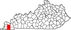 Location of Graves County, Kentucky | |
| CDPs | ||
| Unincorporated communities | ||
| Footnotes | ‡This populated place also has portions in an adjacent county or counties | |
This article is issued from Wikipedia. The text is licensed under Creative Commons - Attribution - Sharealike. Additional terms may apply for the media files.