Pujilí Canton | |
|---|---|
.jpg.webp) Quilotoa, Pujilí Canton | |
.svg.png.webp) Pujilí Canton in Cotopaxi Province | |
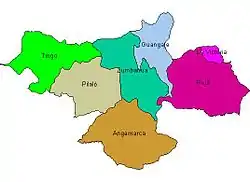 Parishes of Pujilí Canton | |
| Coordinates: 0°57′0″S 78°41′24″W / 0.95000°S 78.69000°W | |
| Country | |
| Province | Cotopaxi Province |
| Capital | Pujilí |
| Area | |
| • Total | 1,329 km2 (513 sq mi) |
| Population (2022 census)[1] | |
| • Total | 66,980 |
| • Density | 50/km2 (130/sq mi) |
| Time zone | UTC-5 (ECT) |
| Website | municipiopujili.gob.ec |
Pujilí Canton is one of seven cantons of the Cotopaxi Province in Ecuador. Its population at the 2001 census was 60,728.[2] Its capital is the town of Pujilí.
Subdivision
The canton is divided into seven parishes, one urban parish, Pujilí, and six rural ones:
- Angamarca
- Guangaje
- La Victoria
- Pílalo
- Tingo
- Zumbahua
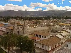 Pujilí
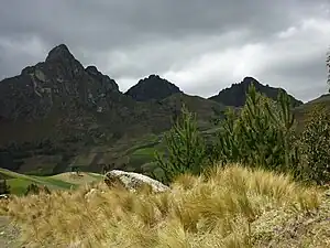 Mountains of Zumbahua
Demographics
Ethnic groups as of the Ecuadorian census of 2010:[3]
- Indigenous 51.8%
- Mestizo 46.1%
- White 1.0%
- Afro-Ecuadorian 0.6%
- Montubio 0.5%
- Other 0.1%
References
- ↑ Citypopulation.de Population and area of Pujilí Canton
- ↑ Cantons of Ecuador at statoids.com
- ↑ "Resultados".
External links
This article is issued from Wikipedia. The text is licensed under Creative Commons - Attribution - Sharealike. Additional terms may apply for the media files.