Puthuppariyaram | |
|---|---|
Suburb | |
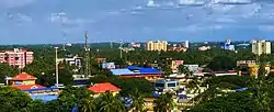 Palakkad city view from Puthupariyaram | |
| Coordinates: 10°48′13″N 76°37′20″E / 10.803631°N 76.622086°E | |
| Country | |
| State | Kerala |
| District | Palakkad |
| Government | |
| • Body | Puthuppariyaram Panchayat |
| Area | |
| • Total | 29.56 km2 (11.41 sq mi) |
| Population (2011) | |
| • Total | 51,185 |
| • Density | 1,731.56/km2 (4,484.7/sq mi) |
| Languages | |
| • Official | Malayalam, English |
| Time zone | UTC+5:30 (IST) |
| PIN | 678731 |
| Vehicle registration | KL-9 |
| Parliament constituency | Palakkad |
| Assembly constituency | Malampuzha |
Puthuppariyaram is a suburb of Palakkad city in Palakkad District of Kerala,India.[1] Puthuppariyaram lies on National Highway 966[2] and is located about 5 km from district headquarters and 124 km from Kozhikode. Puthuppariyaram Panchayat is one among the Panchayat which is supposed to be part of proposed Palakkad Municipal Corporation.[3]
Demographics
As of 2011 India census, Puthuppariyaram had a population of 51185 with a density of 1731.56 km^2 over an area of 29.56 Sq.Km.[4]
References
- ↑ "Pin Code: PUDUPPARIYARAM, PALAKKAD, KERALA, India, Pincode.net.in". pincode.net.in. Retrieved 20 August 2022.
- ↑ "NH 966".
- ↑ "19 2 19p1 — Postimages". postlmg.cc. Retrieved 17 June 2022.
- ↑ "പാലക്കാട് ജില്ലയിലെ ഗ്രാമ പഞ്ചായത്തുകളുടെ അടിസ്ഥാന വിവരങ്ങള് | പഞ്ചായത്ത് വകുപ്പ്". dop.lsgkerala.gov.in. Retrieved 20 August 2022.
Wikimedia Commons has media related to Malampuzha.
This article is issued from Wikipedia. The text is licensed under Creative Commons - Attribution - Sharealike. Additional terms may apply for the media files.