Route 345 | ||||
|---|---|---|---|---|
 | ||||
| Route information | ||||
| Maintained by Transports Québec | ||||
| Length | 19.8 km[1] (12.3 mi) | |||
| Major junctions | ||||
| South end | ||||
| North end | ||||
| Location | ||||
| Country | Canada | |||
| Province | Quebec | |||
| Major cities | Saint-Félix-de-Valois | |||
| Highway system | ||||
| ||||

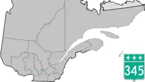
Route 345 is a provincial highway located in the Lanaudière region of Quebec. It runs from the junction of Route 158 in Sainte-Geneviève-de-Berthier and ends at the junction of Route 131 in Saint-Felix-de-Valois.
Municipalities along Route 345
Major intersections
| RCM | Location | km | mi | Destinations | Notes |
|---|---|---|---|---|---|
| D'Autray | Sainte-Geneviève-de-Berthier | 0 | 0.0 | Rotary; southern terminus | |
| Matawinie | Saint-Félix-de-Valois | 12.3 | 7.6 | Nouthern terminus | |
| 1.000 mi = 1.609 km; 1.000 km = 0.621 mi | |||||
See also
References
- ↑ Ministère des transports, "Distances routières", page 100, Les Publications du Québec, 2005
External links
- Transport Quebec official map (in French)
- Route 345 on Google Maps
This article is issued from Wikipedia. The text is licensed under Creative Commons - Attribution - Sharealike. Additional terms may apply for the media files.