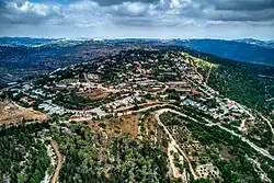
Ramat Raziel
רמת רזיאל | |
|---|---|
 | |
 Ramat Raziel | |
| Coordinates: 31°46′26″N 35°4′22″E / 31.77389°N 35.07278°E | |
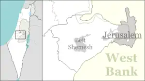
| Country | Israel |
| District | Jerusalem |
| Council | Mateh Yehuda |
| Affiliation | Mishkei Herut Beitar |
| Founded | 1948 |
| Population (2021)[1] | 662 |
Ramat Raziel (Hebrew: רָמַת רָזִיאֵל, lit. 'Raziel Heights') is a moshav in central Israel. Located in the centre of the Jerusalem corridor, it falls under the jurisdiction of Mateh Yehuda Regional Council. In 2021 it had a population of 662.[1]
History
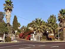
Entrance to Ramat Raziel
The village was established in 1948 on land that had belonged to the depopulated Palestinian village of Kasla.[2] It was named after David Raziel, chief commander of the Irgun.[3][4]
Despite the difficult terrain, the economy was based on farming.[5] In 1988 Eli Ben-Zaken planted vineyards and established Domaine du Castel, an award-winning winery, in Ramat Raziel.[6]
References
- 1 2 "Regional Statistics". Israel Central Bureau of Statistics. Retrieved 22 February 2023.
- ↑ Khalidi, Walid (1992). All That Remains: The Palestinian Villages Occupied and Depopulated by Israel in 1948. Washington D.C.: Institute for Palestine Studies. p. 299. ISBN 0-88728-224-5.
- ↑ David Raziel
- ↑ David Raziel Jewish Virtual Library
- ↑ Ramat Raziel
- ↑ Castel: Wine and the wonder of Israel The Jerusalem Post
This article is issued from Wikipedia. The text is licensed under Creative Commons - Attribution - Sharealike. Additional terms may apply for the media files.