Rettenegg | |
|---|---|
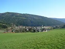 View of Rattenegg | |
 Coat of arms | |
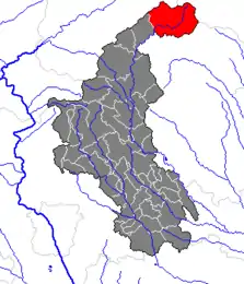 Location within Weiz district | |
 Rettenegg Location within Austria | |
| Coordinates: 47°31′33″N 15°46′49″E / 47.52583°N 15.78028°E | |
| Country | Austria |
| State | Styria |
| District | Weiz |
| Government | |
| • Mayor | Johann Ziegerhofer (ÖVP) |
| Area | |
| • Total | 78.87 km2 (30.45 sq mi) |
| Elevation | 862 m (2,828 ft) |
| Population (2018-01-01)[2] | |
| • Total | 741 |
| • Density | 9.4/km2 (24/sq mi) |
| Time zone | UTC+1 (CET) |
| • Summer (DST) | UTC+2 (CEST) |
| Postal code | 8674 |
| Area code | 03173 |
| Vehicle registration | WZ |
| Website | www.rettenegg.at |
Rettenegg is a municipality in the district of Weiz in the Austrian state of Styria.
Geography
Rettenegg lies in the Fischbach Alps at the confluence of the Pfaffenbach and the Feistritz.
References
- ↑ "Dauersiedlungsraum der Gemeinden Politischen Bezirke und Bundesländer - Gebietsstand 1.1.2018". Statistics Austria. Retrieved 10 March 2019.
- ↑ "Einwohnerzahl 1.1.2018 nach Gemeinden mit Status, Gebietsstand 1.1.2018". Statistics Austria. Retrieved 9 March 2019.
This article is issued from Wikipedia. The text is licensed under Creative Commons - Attribution - Sharealike. Additional terms may apply for the media files.