| Fynn | |
|---|---|
 | |
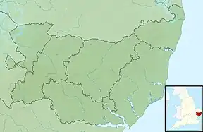 Location of the river mouth within Suffolk | |
| Location | |
| Country | England |
| Region | Suffolk |
| Physical characteristics | |
| Source | |
| • location | Witnesham[1] |
| • coordinates | 52°16′48″N 1°18′17″E / 52.2799°N 1.3048°E |
| • elevation | 60 m (200 ft) |
| Mouth | |
• location | Martlesham[1] |
• coordinates | 52°04′36″N 1°17′43″E / 52.07667°N 1.295313°E |
• elevation | 0 m (0 ft) |
| Length | 13.622 km (8.464 mi)[1] |
| Basin features | |
| River system | River Deben[1] |
| Water Body ID | GB105035040330[1] |
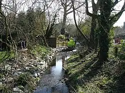
The River Fynn is a waterway in Suffolk which joins the River Deben. Its source is at Witnesham and it joins the Deben at Woodbridge.[2]
Wikimedia Commons has media related to Category:River Fynn.
References
- 1 2 3 4 5 "Fynn | Catchment Data Explorer | Catchment Data Explorer". environment.data.gov.uk. Department for Environment Food & Rural Affairs. Retrieved 5 October 2023.
- ↑ "Fynn Valley Walk Route". www.gps-routes.co.uk. GPS Cycle and Walking Routes. Retrieved 5 October 2023.
This article is issued from Wikipedia. The text is licensed under Creative Commons - Attribution - Sharealike. Additional terms may apply for the media files.