| Roaring River | |
|---|---|
| Location | |
| Country | United States |
| State | Missouri |
| Region | Ozark Plateau |
| Physical characteristics | |
| Source | Roaring River Spring |
| • location | Salem Plateau, Ozark Plateau, Missouri |
| • coordinates | 36°38′38″N 93°48′32″W / 36.64389°N 93.80889°W[1] |
| Mouth | White River |
• location | Barry County, Ozark Plateau, Missouri |
• coordinates | 36°32′16″N 93°42′59″W / 36.53778°N 93.71639°W[1] |
| Length | 14.9 mi (24.0 km) |
| Discharge | |
| • location | Roaring River State Park |
| • average | 71 cu/ft. per sec.[2] |
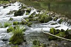
The water rippling over the rocks at Roaring River State Park.
The Roaring River is a 14.9-mile-long (24.0 km)[3] river in Barry County, Missouri, in the Ozarks. It is a tributary of the White River, into which it flows in Eagle Rock, Missouri. This section of the White River is a reservoir called Table Rock Lake.
The stream was named on account of roaring waters from a cave along its course.[4]
See also
References
- 1 2 "Roaring River". Geographic Names Information System. United States Geological Survey. Retrieved 2014-01-26.
- ↑ "USGS Surface Water data for Missouri: USGS Surface-Water Annual Statistics".
- ↑ U.S. Geological Survey. National Hydrography Dataset high-resolution flowline data. The National Map, accessed March 9, 2011
- ↑ "Barry County Place Names, 1928-1945 (archived)". The State Historical Society of Missouri. Archived from the original on 24 June 2016. Retrieved 30 August 2016.
{{cite web}}: CS1 maint: bot: original URL status unknown (link)
This article is issued from Wikipedia. The text is licensed under Creative Commons - Attribution - Sharealike. Additional terms may apply for the media files.