Rocca di Mezzo | |
|---|---|
| Comune di Rocca di Mezzo | |
 | |
 Coat of arms | |
Location of Rocca di Mezzo | |
 Rocca di Mezzo Location of Rocca di Mezzo in Italy 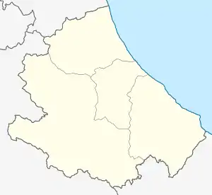 Rocca di Mezzo Rocca di Mezzo (Abruzzo) | |
| Coordinates: 42°12′21″N 13°31′13″E / 42.20583°N 13.52028°E | |
| Country | Italy |
| Region | Abruzzo |
| Province | L'Aquila (AQ) |
| Frazioni | Fonteavignone, Rovere, Terranera |
| Government | |
| • Mayor | Mauro Di Ciccio |
| Area | |
| • Total | 86.95 km2 (33.57 sq mi) |
| Elevation | 1,329 m (4,360 ft) |
| Population (31 December 2010)[2] | |
| • Total | 1,556 |
| • Density | 18/km2 (46/sq mi) |
| Demonym | Rocchigiani |
| Time zone | UTC+1 (CET) |
| • Summer (DST) | UTC+2 (CEST) |
| Postal code | 67048 |
| Dialing code | 0862 |
| Patron saint | St. Leucius |
| Saint day | 11 January |
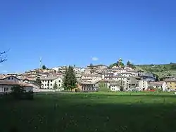
Rocca di Mezzo (locally La Rocca) is a comune and town in the Province of L'Aquila, in the Abruzzo region of central Italy.
It is home to the seat of the Sirente-Velino Regional Park.
References
- ↑ "Superficie di Comuni Province e Regioni italiane al 9 ottobre 2011". Italian National Institute of Statistics. Retrieved 16 March 2019.
- ↑ All demographics and other statistics: Italian statistical institute Istat.
This article is issued from Wikipedia. The text is licensed under Creative Commons - Attribution - Sharealike. Additional terms may apply for the media files.