Rogat | |
|---|---|
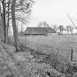 Farm in Rogat | |
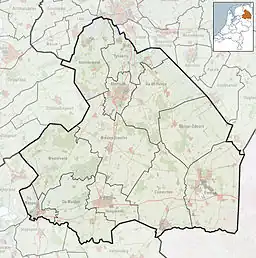 Rogat Location of the village in the province of Drenthe  Rogat Rogat (Netherlands) | |
| Coordinates: 52°41′15″N 6°16′0″E / 52.68750°N 6.26667°E | |
| Country | Netherlands |
| Province | Drenthe |
| Municipality | Meppel |
| Area | |
| • Total | 1.54 km2 (0.59 sq mi) |
| Elevation | 3 m (10 ft) |
| Population (2021)[1] | |
| • Total | 120 |
| • Density | 78/km2 (200/sq mi) |
| Time zone | UTC+1 (CET) |
| • Summer (DST) | UTC+2 (CEST) |
| Postal code | 7949[1] |
| Dialing code | 0522 |
Rogat is a village in the Dutch province of Drenthe.[3] It is a part of the municipality of Meppel, and lies about 5 km east of Meppel.
It was first mentioned in 1725 as Rogatschut, and means "chimney".[4] It has partially become an industrial area. The hamlet contains about 40 houses.[5]
References
- 1 2 3 "Kerncijfers wijken en buurten 2021". Central Bureau of Statistics. Retrieved 13 March 2022.
- ↑ "Postcodetool for 7949AA". Actueel Hoogtebestand Nederland (in Dutch). Het Waterschapshuis. Retrieved 12 March 2022.
- ↑ AM. "Rogat, Netherlands". places-in-the-world.com. Retrieved 11 November 2015.
- ↑ "Rogat - (geografische naam)". Etymologiebank (in Dutch). Retrieved 13 March 2022.
- ↑ "Rogat". Plaatsengids (in Dutch). Retrieved 13 March 2022.
This article is issued from Wikipedia. The text is licensed under Creative Commons - Attribution - Sharealike. Additional terms may apply for the media files.