Rozsochatec | |
|---|---|
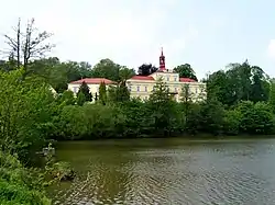 Rozsochatec Castle | |
 Flag  Coat of arms | |
 Rozsochatec Location in the Czech Republic | |
| Coordinates: 49°40′21″N 15°38′2″E / 49.67250°N 15.63389°E | |
| Country | |
| Region | Vysočina |
| District | Havlíčkův Brod |
| First mentioned | 1283 |
| Area | |
| • Total | 9.25 km2 (3.57 sq mi) |
| Elevation | 480 m (1,570 ft) |
| Population (2023-01-01)[1] | |
| • Total | 527 |
| • Density | 57/km2 (150/sq mi) |
| Time zone | UTC+1 (CET) |
| • Summer (DST) | UTC+2 (CEST) |
| Postal codes | 580 01, 582 72 |
| Website | rozsochatec |
Rozsochatec is a municipality and village in Havlíčkův Brod District in the Vysočina Region of the Czech Republic. It has about 500 inhabitants.
Rozsochatec lies approximately 10 kilometres (6 mi) north-east of Havlíčkův Brod, 32 km (20 mi) north of Jihlava, and 98 km (61 mi) south-east of Prague.
Administrative parts
The village of Jahodov is an administrative part of Rozsochatec.
History
The first written mention of Rozsochatec is from 1283.[2]
Gallery
 Castle pond
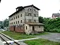 Train station
References
- ↑ "Population of Municipalities – 1 January 2023". Czech Statistical Office. 2023-05-23.
- ↑ "Historie obce" (in Czech). Obec Rozsochatec. Retrieved 2022-07-15.
Wikimedia Commons has media related to Rozsochatec.
This article is issued from Wikipedia. The text is licensed under Creative Commons - Attribution - Sharealike. Additional terms may apply for the media files.