Safana | |
|---|---|
LGA and town | |
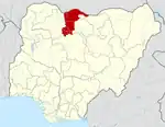
 Safana Location in Nigeria | |
| Coordinates: 12°30′N 7°14′E / 12.500°N 7.233°E | |
| Country | |
| State | Katsina State |
| established | 1989 |
| Government | |
| • Chairman | Abba dayyabu safana |
| Area | |
| • Total | 282 km2 (109 sq mi) |
| Population (2006 census) | |
| • Total | 183,779 |
| Time zone | UTC+1 (WAT) |
| 3-digit postal code prefix | 821 |
| ISO 3166 code | NG.KT.SA |
Safana is a Local Government Area in Katsina State, Nigeria. Its headquarters is located in the town of Safana in the east of the area at12°24′30″N 7°24′25″E / 12.40833°N 7.40694°E. The western border of the area is shared with Zamfara State. And has two district heads yariman katsina and gatarin katsina It has an area of 282 km2 and a population of 183,779 at the 2006 census.
The postal code of the area is 821.[1]
Climate
With an average yearly temperature of 30.42°C, 50.83mm of precipitation, and 53.8 days with rain, Safana, Nigeria, has a subtropical steppe climate.[2][3]
References
- ↑ "Post Offices- with map of LGA". NIPOST. Archived from the original on 2012-11-26. Retrieved 2009-10-20.
- ↑ "Safana, Katsina, NG Climate Zone, Monthly Averages, Historical Weather Data". tcktcktck.org. Retrieved 2023-08-29.
- ↑ "Safana Climate, Weather By Month, Average Temperature (Nigeria) - Weather Spark". weatherspark.com. Retrieved 2023-08-29.
State capital: Katsina | ||
| Topics |
|  |
| LGAs | ||
This article is issued from Wikipedia. The text is licensed under Creative Commons - Attribution - Sharealike. Additional terms may apply for the media files.