Saint-Étienne-en-Dévoluy | |
|---|---|
Part of Dévoluy | |
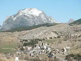 The village of Saint-Étienne-en-Dévoluy, with the south face of Le Gicon in the background | |
 Coat of arms | |
Location of Saint-Étienne-en-Dévoluy | |
 Saint-Étienne-en-Dévoluy 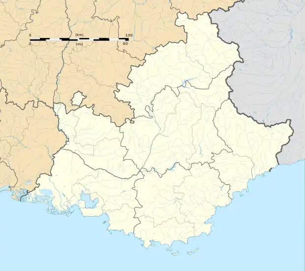 Saint-Étienne-en-Dévoluy | |
| Coordinates: 44°41′36″N 5°56′31″E / 44.6933°N 5.9419°E | |
| Country | France |
| Region | Provence-Alpes-Côte d'Azur |
| Department | Hautes-Alpes |
| Arrondissement | Gap |
| Canton | Saint-Étienne-en-Dévoluy |
| Commune | Dévoluy |
| Area 1 | 67.87 km2 (26.20 sq mi) |
| Population (2019)[1] | 476 |
| • Density | 7.0/km2 (18/sq mi) |
| Time zone | UTC+01:00 (CET) |
| • Summer (DST) | UTC+02:00 (CEST) |
| Postal code | 05250 |
| Elevation | 1,134–2,652 m (3,720–8,701 ft) (avg. 1,263 m or 4,144 ft) |
| 1 French Land Register data, which excludes lakes, ponds, glaciers > 1 km2 (0.386 sq mi or 247 acres) and river estuaries. | |
Saint-Étienne-en-Dévoluy (Vivaro-Alpine: Sant Estève de Devolui) is a former commune in the Hautes-Alpes department in southeastern France. On 1 January 2013, Agnières-en-Dévoluy, La Cluse, Saint-Disdier, and Saint-Étienne-en-Dévoluy amalgamated into the new commune of Dévoluy.
SuperDévoluy, a ski resort, was part of the commune.
Climate
| Climate data for Saint-Étienne-en-Dévoluy (1991–2020 averages): elevation 1300m | |||||||||||||
|---|---|---|---|---|---|---|---|---|---|---|---|---|---|
| Month | Jan | Feb | Mar | Apr | May | Jun | Jul | Aug | Sep | Oct | Nov | Dec | Year |
| Record high °C (°F) | 15.1 (59.2) |
18.2 (64.8) |
22.0 (71.6) |
24.1 (75.4) |
29.8 (85.6) |
33.5 (92.3) |
34.4 (93.9) |
34.3 (93.7) |
30.0 (86.0) |
26.3 (79.3) |
20.0 (68.0) |
15.3 (59.5) |
34.4 (93.9) |
| Mean daily maximum °C (°F) | 3.5 (38.3) |
4.7 (40.5) |
9.0 (48.2) |
12.4 (54.3) |
16.8 (62.2) |
21.3 (70.3) |
24.1 (75.4) |
23.8 (74.8) |
18.7 (65.7) |
13.9 (57.0) |
7.5 (45.5) |
4.0 (39.2) |
13.3 (56.0) |
| Daily mean °C (°F) | −1.5 (29.3) |
−0.9 (30.4) |
2.9 (37.2) |
6.1 (43.0) |
10.5 (50.9) |
14.2 (57.6) |
16.4 (61.5) |
16.2 (61.2) |
12.1 (53.8) |
8.3 (46.9) |
2.9 (37.2) |
−0.5 (31.1) |
7.2 (45.0) |
| Mean daily minimum °C (°F) | −6.5 (20.3) |
−6.6 (20.1) |
−3.1 (26.4) |
−0.1 (31.8) |
4.1 (39.4) |
7.2 (45.0) |
8.7 (47.7) |
8.7 (47.7) |
5.5 (41.9) |
2.6 (36.7) |
−1.7 (28.9) |
−5.1 (22.8) |
1.1 (34.1) |
| Record low °C (°F) | −25 (−13) |
−25.1 (−13.2) |
−19.5 (−3.1) |
−11 (12) |
−5 (23) |
−2.7 (27.1) |
1.0 (33.8) |
−0.3 (31.5) |
−4.5 (23.9) |
−9.2 (15.4) |
−20 (−4) |
−19.9 (−3.8) |
−25.1 (−13.2) |
| Average precipitation mm (inches) | 84.3 (3.32) |
58.7 (2.31) |
71.0 (2.80) |
93.8 (3.69) |
95.0 (3.74) |
78.3 (3.08) |
58.9 (2.32) |
68.9 (2.71) |
95.5 (3.76) |
138.1 (5.44) |
156.7 (6.17) |
101.4 (3.99) |
1,100.6 (43.33) |
| Source: Météo-France[2] | |||||||||||||
Population
| Year | Pop. | ±% p.a. |
|---|---|---|
| 2006 | 587 | — |
| 2010 | 558 | −1.26% |
| 2019 | 476 | −1.75% |
| Source: INSEE[3][4][1] | ||
See also
References
- 1 2 Téléchargement du fichier d'ensemble des populations légales en 2019, INSEE
- ↑ "Fiche Climatologique Statistiques 1991-2020 et records" (PDF). Météo-France. Retrieved September 6, 2023.
- ↑ Populations légales 2006, INSEE
- ↑ Populations légales 2010, INSEE
Wikimedia Commons has media related to Saint-Étienne-en-Dévoluy.
This article is issued from Wikipedia. The text is licensed under Creative Commons - Attribution - Sharealike. Additional terms may apply for the media files.