Saint-Cléophas-de-Brandon | |
|---|---|
 | |
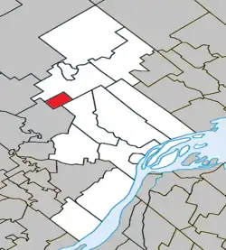 Location within D'Autray RCM. | |
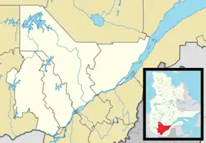 Saint-Cléophas-de-Brandon Location in central Quebec. | |
| Coordinates: 46°14′N 73°25′W / 46.233°N 73.417°W[1] | |
| Country | |
| Province | |
| Region | Lanaudière |
| RCM | D'Autray |
| Constituted | October 7, 1897 |
| Government | |
| • Mayor | Denis Gamelin |
| • Federal riding | Berthier—Maskinongé |
| • Prov. riding | Berthier |
| Area | |
| • Total | 15.30 km2 (5.91 sq mi) |
| • Land | 15.34 km2 (5.92 sq mi) |
| There is an apparent contradiction between two authoritative sources. | |
| Population (2021)[3] | |
| • Total | 254 |
| • Density | 16.6/km2 (43/sq mi) |
| • Pop 2016-2021 | |
| • Dwellings | 112 |
| Time zone | UTC−5 (EST) |
| • Summer (DST) | UTC−4 (EDT) |
| Postal code(s) | |
| Area code(s) | 450 and 579 |
| Highways | |
| Website | www |
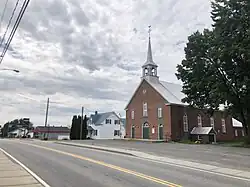
Saint-Cléophas-de-Brandon is a municipality in D'Autray Regional County Municipality in the Lanaudière region of Quebec, Canada. Before 1997 it was known simply as Saint-Cléophas.
History
In 1897, the Parish of Saint-Cléophas was formed when it separated from the parish of Saint-Félix-de-Valois. It seems that the name of Saint Cléophas was suggested by Édouard-Charles Fabre (1827-1896), archbishop of Montreal, to honour Cléophas Beausoleil (1845-1904), who was House of Commons member for Berthier from 1887 to 1899. That same year, its post office opened and a year later the Parish Municipality of Saint-Cléophas was established.[1]
In 1997, the parish municipality changed status to municipality and changed its name to Saint-Cléophas-de-Brandon in order to distinguish it from a namesake municipality in the Bas-Saint-Laurent region. The "Brandon" part refers to the geographic township of Brandon within which it is located.[1]
Geography
Inserted between Saint-Gabriel-de-Brandon to the north and Saint-Norbert to the east, between the edge of the Laurentians and Saint-Félix-de-Valois, along the Bayonne River, Saint-Cléophas-de-Brandon is characterized by a landscape of hills and plains.
Demographics
Population trend:[4]
- Population in 2021: 254 (2016 to 2021 population change: 11.9%)
- Population in 2016: 227
- Population in 2011: 276
- Population in 2006: 284
- Population in 2001: 285
- Population in 1996: 283
- Population in 1991: 262
Private dwellings occupied by usual residents: 105 (total dwellings: 112)
Mother tongue:
- English as first language: 0%
- French as first language: 100%
- English and French as first language: 0%
- Other as first language: 0%
Education
The Sir Wilfrid Laurier School Board operates anglophone public schools, including:
- Joliette Elementary School in Saint-Charles-Borromée[5]
- Joliette High School in Joliette[6]
See also
References
- 1 2 3 "Saint-Cléophas-de-Brandon (Municipalité)" (in French). Commission de toponymie du Québec. Retrieved 2009-11-17.
- 1 2 "Répertoire des municipalités: Geographic code 52075". www.mamh.gouv.qc.ca (in French). Ministère des Affaires municipales et de l'Habitation.
- 1 2 Statistics Canada 2021 Census - Saint-Cléophas-de-Brandon census profile
- ↑ Statistics Canada: 1996, 2001, 2006, 2011, 2016, 2021 census
- ↑ "JOLIETTE ELEMENTARY ZONE." Sir Wilfrid Laurier School Board. Retrieved on September 17, 2017.
- ↑ "Joliette High School Zone Sec 1-5." Sir Wilfrid Laurier School Board. Retrieved on September 5, 2017.
External links
Adjacent Municipal Subdivisions | ||||||||||||||||
|---|---|---|---|---|---|---|---|---|---|---|---|---|---|---|---|---|
| ||||||||||||||||
| Cities & Towns | |
|---|---|
| Municipalities | |
| Parishes | |
| |