Sainte-Rose-de-Watford | |
|---|---|
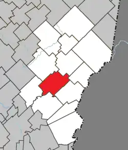 Location within Les Etchemins RCM. | |
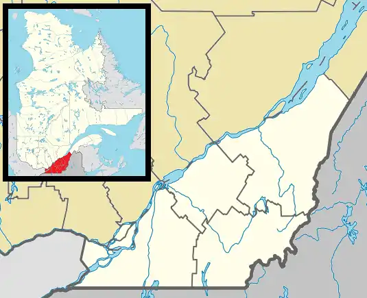 Sainte-Rose-de-Watford Location in southern Quebec. | |
| Coordinates: 46°19′N 70°25′W / 46.317°N 70.417°W[1] | |
| Country | Canada |
| Province | Quebec |
| Region | Chaudière-Appalaches |
| RCM | Les Etchemins |
| Constituted | November 17, 1897 |
| Government | |
| • Mayor | Jean Bernier |
| • Federal riding | Lévis—Bellechasse |
| • Prov. riding | Bellechasse |
| Area | |
| • Total | 115.70 km2 (44.67 sq mi) |
| • Land | 115.50 km2 (44.59 sq mi) |
| Population (2011)[3] | |
| • Total | 787 |
| • Density | 6.8/km2 (18/sq mi) |
| • Pop 2006-2011 | |
| • Dwellings | 414 |
| Time zone | UTC−5 (EST) |
| • Summer (DST) | UTC−4 (EDT) |
| Postal code(s) | |
| Area code(s) | 418 and 581 |
| Highways | |
| Website | www.sainterose dewatford.qc.ca |
Sainte-Rose-de-Watford is a municipality in the Municipalité régionale de comté des Etchemins in Quebec, Canada. It is part of the Chaudière-Appalaches region and the population is 747 as of 2009. It is named after Rose of Lima, the first Catholic saint of the Americas and Watford, a town in Hertfordshire, England.
References
- ↑ "Banque de noms de lieux du Québec: Reference number 56387". toponymie.gouv.qc.ca (in French). Commission de toponymie du Québec.
- 1 2 "Répertoire des municipalités: Geographic code 28030". www.mamh.gouv.qc.ca (in French). Ministère des Affaires municipales et de l'Habitation.
- 1 2 "Sainte-Rose-de-Watford, Quebec (Code 2428030) Census Profile". 2011 census. Government of Canada - Statistics Canada.
- Commission de toponymie du Québec
- Ministère des Affaires municipales, des Régions et de l'Occupation du territoire
Places adjacent to Sainte-Rose-de-Watford, Quebec | ||||||||||||||||
|---|---|---|---|---|---|---|---|---|---|---|---|---|---|---|---|---|
| ||||||||||||||||
| Municipalities | |
|---|---|
| Parishes | |
| |
This article is issued from Wikipedia. The text is licensed under Creative Commons - Attribution - Sharealike. Additional terms may apply for the media files.