Salme Parish
Salme vald | |
|---|---|
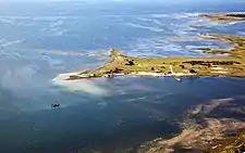 Lõmala harbour | |
 Flag  Coat of arms | |
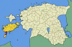 Salme Parish within Saare County. | |
| Country | |
| County | |
| Administrative centre | Salme |
| Government | |
| • Mayor | Kalmer Poopuu |
| Area | |
| • Total | 115.07 km2 (44.43 sq mi) |
| Population (01.01.2009) | |
| • Total | 1,249 |
| • Density | 11/km2 (28/sq mi) |
Salme Parish was a municipality in Saare County, Estonia. It contained the northern half of the Sõrve Peninsula of the island of Saaremaa.
Besides the small borough Salme there were 24 villages: Anseküla, Easte, Hindu, Imara, Järve, Kaimri, Kaugatoma, Läätsa, Lahetaguse, Länga, Lassi, Lõmala, Lõu, Metsalõuka, Mõisaküla, Möldri, Rahuste, Suurna, Tehumardi, Tiirimetsa, Toomalõuka, Ula, Üüdibe, Vintri.
Prior to 1936, the municipality was called Abruka. During the Second World War, the Battle of Tehumardi took place in Salme. The location is marked by a 21-metre Soviet monument.
During the administrative-territorial reform in 2017, all 12 municipalities on the island Saaremaa were merged into a single municipality – Saaremaa Parish.[1]
See also
- Municipalities of Estonia
- List of municipalities of Estonia
- The Salme ships - Two clinker-built ships with the remains of 40 persons was found autumn 2008.[2][3]
References
- ↑ "Kihelkonna valla, Kuressaare linna, Laimjala valla, Leisi valla, Lääne-Saare valla, Mustjala valla, Orissaare valla, Pihtla valla, Pöide valla, Salme valla, Torgu valla ja Valjala valla osas haldusterritoriaalse korralduse ja Vabariigi Valitsuse 3. aprilli 1995. a määruse nr 159 "Eesti territooriumi haldusüksuste nimistu kinnitamine" muutmine". Riigi Teataja (in Estonian). Retrieved 11 December 2017.
- ↑ The Salme shipfind blog
- ↑ The First Vikings
58°09′41″N 22°14′59″E / 58.16139°N 22.24972°E
| Rural municipality | ||
|---|---|---|