Salto | |
|---|---|
Municipality | |
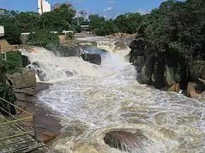 View of the Tietê River, through the dam of Salto | |
 Flag  Coat of arms | |
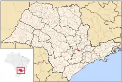 Location in São Paulo state | |
 Salto Location in Brazil | |
| Coordinates: 23°12′3″S 47°17′13″W / 23.20083°S 47.28694°W | |
| Country | |
| Region | Southeast Brazil |
| State | São Paulo |
| Metropolitan Region | Sorocaba |
| Microregion | Sorocaba |
| Government | |
| • Prefect | Juvenil Cirelli (PT) |
| Area | |
| • Total | 133.06 km2 (51.37 sq mi) |
| Elevation | 555 m (1,821 ft) |
| Population (2020 [1]) | |
| • Total | 119,736 |
| • Density | 900/km2 (2,300/sq mi) |
| Time zone | UTC-3 (BRT) |
| • Summer (DST) | UTC-2 (BRST) |
| Website | www |
Salto is a municipality in the state of São Paulo in Brazil. It is part of the Metropolitan Region of Sorocaba.[2] The population is 119,736 (2020 est.) in an area of 133.06 km².[3] The elevation is 555 m. The city has one main river, rio Tietê. The city has an important geological park, the Moutonée Park.
References
- ↑ IBGE 2020
- ↑ "Governo do Estado de São Paulo, Lei Complementar nº 1.241, de 8 de maio de 2014". Archived from the original on 18 October 2014. Retrieved 2015-09-29.
{{cite web}}: CS1 maint: bot: original URL status unknown (link) - ↑ Instituto Brasileiro de Geografia e Estatística
This article is issued from Wikipedia. The text is licensed under Creative Commons - Attribution - Sharealike. Additional terms may apply for the media files.