Samlout | |
|---|---|
 Samlout Map highlighting Samlout | |
| Coordinates: 12°38′01″N 102°45′14″E / 12.6336°N 102.7538°E | |
| Country | |
| Province | Battambang Province |
| District | Samlout District |
| Villages | 6 |
| Time zone | UTC+07 |
| Geocode | 020905 |
Samlout is a khum (commune) of Samlout District in Battambang Province in north-western Cambodia.[1]
It is the principal town of Samlout District.
Villages
- Chhar RoKar
- Kantuot
- Ou Chrab
- Samlout
- Srae Andoung Muy
- Bueng Run
References
- ↑ "Statistics of the Cambodian Government". Archived from the original on 2008-12-24.
Capital: Battambang | ||
| Banan District | 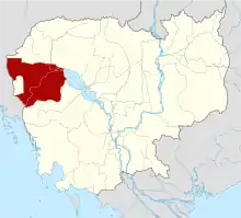 | |
| Thma Koul District | ||
| Battambang Municipality (city) | ||
| Bavel District |
| |
| Ek Phnom District | ||
| Moung Ruessei District | ||
| Rotanak Mondol District |
| |
| Sangkae District | ||
| Samlout District | ||
| Sampov Loun District | ||
| Phnum Proek District | ||
| Kamrieng District | ||
| Koas Krala District | ||
| Rukhak Kiri District |
| |
This article is issued from Wikipedia. The text is licensed under Creative Commons - Attribution - Sharealike. Additional terms may apply for the media files.