Sankt Andrä | |
|---|---|
 | |
.svg.png.webp) Coat of arms | |
 Sankt Andrä Location within Austria | |
| Coordinates: 46°46′N 14°49′E / 46.767°N 14.817°E | |
| Country | Austria |
| State | Carinthia |
| District | Wolfsberg |
| Government | |
| • Mayor | Peter Stauber |
| Area | |
| • Total | 113.47 km2 (43.81 sq mi) |
| Elevation | 446 m (1,463 ft) |
| Population (2018-01-01)[2] | |
| • Total | 9,957 |
| • Density | 88/km2 (230/sq mi) |
| Time zone | UTC+1 (CET) |
| • Summer (DST) | UTC+2 (CEST) |
| Postal code | 9433 |
| Area code | 04358 |
| Website | www.st-andrae.at |
Sankt Andrä (Slovene: Sveti Andrej) is a town in the district of Wolfsberg in Carinthia in Austria. It is named after Saint Andrew.
Landmarks
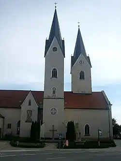
The main church is Saint Andrew's Church, until 1859 a cathedral and the bishop's seat of the Diocese of Lavant.
Population
| Year | Pop. | ±% |
|---|---|---|
| 1869 | 6,515 | — |
| 1880 | 6,686 | +2.6% |
| 1890 | 6,716 | +0.4% |
| 1900 | 6,708 | −0.1% |
| 1910 | 6,625 | −1.2% |
| 1923 | 6,646 | +0.3% |
| 1934 | 6,934 | +4.3% |
| 1939 | 7,356 | +6.1% |
| 1951 | 7,987 | +8.6% |
| 1961 | 9,131 | +14.3% |
| 1971 | 10,174 | +11.4% |
| 1981 | 10,400 | +2.2% |
| 1991 | 10,582 | +1.8% |
| 2001 | 10,719 | +1.3% |
| 2011 | 10,332 | −3.6% |
| 2021 | 9,850 | −4.7% |
References
- ↑ "Dauersiedlungsraum der Gemeinden Politischen Bezirke und Bundesländer - Gebietsstand 1.1.2018". Statistics Austria. Retrieved 10 March 2019.
- ↑ "Einwohnerzahl 1.1.2018 nach Gemeinden mit Status, Gebietsstand 1.1.2018". Statistics Austria. Retrieved 9 March 2019.
External links
Wikimedia Commons has media related to Sankt Andrä, Kärnten.
This article is issued from Wikipedia. The text is licensed under Creative Commons - Attribution - Sharealike. Additional terms may apply for the media files.