Sankt Andrä im Lungau | |
|---|---|
 | |
 Coat of arms | |
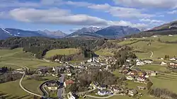
 Sankt Andrä im Lungau Location within Austria | |
| Coordinates: 47°08′56″N 13°47′49″E / 47.14889°N 13.79694°E | |
| Country | Austria |
| State | Salzburg |
| District | Tamsweg |
| Government | |
| • Mayor | Heinrich Perner (ÖVP) |
| Area | |
| • Total | 10.50 km2 (4.05 sq mi) |
| Elevation | 1,055 m (3,461 ft) |
| Population (2018-01-01)[2] | |
| • Total | 761 |
| • Density | 72/km2 (190/sq mi) |
| Time zone | UTC+1 (CET) |
| • Summer (DST) | UTC+2 (CEST) |
| Postal code | 5572 |
| Area code | 06474 |
| Vehicle registration | TA |
| Website | www.st-andrae.salzburg.at |
Sankt Andrä im Lungau is a municipality in the district of Tamsweg in the state of Salzburg in Austria.
See also
References
- ↑ "Dauersiedlungsraum der Gemeinden Politischen Bezirke und Bundesländer - Gebietsstand 1.1.2018". Statistics Austria. Retrieved 10 March 2019.
- ↑ "Einwohnerzahl 1.1.2018 nach Gemeinden mit Status, Gebietsstand 1.1.2018". Statistics Austria. Retrieved 9 March 2019.
This article is issued from Wikipedia. The text is licensed under Creative Commons - Attribution - Sharealike. Additional terms may apply for the media files.