Sankt Marienkirchen an der Polsenz | |
|---|---|
 | |
 Coat of arms | |
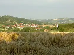
 Sankt Marienkirchen an der Polsenz Location within Austria | |
| Coordinates: 48°15′50″N 13°55′50″E / 48.26389°N 13.93056°E | |
| Country | Austria |
| State | Upper Austria |
| District | Eferding |
| Government | |
| • Mayor | Josef Dopler (ÖVP) |
| Area | |
| • Total | 23.84 km2 (9.20 sq mi) |
| Elevation | 315 m (1,033 ft) |
| Population (2018-01-01)[2] | |
| • Total | 2,337 |
| • Density | 98/km2 (250/sq mi) |
| Time zone | UTC+1 (CET) |
| • Summer (DST) | UTC+2 (CEST) |
| Postal code | 4076, 4075, 4732 |
| Area code | 07249 |
| Vehicle registration | EF |
| Website | st-marienkirchen-polsenz |
Sankt Marienkirchen an der Polsenz is a municipality in the district of Eferding in the Austrian state of Upper Austria.
Population
| Year | Pop. | ±% |
|---|---|---|
| 1869 | 2,088 | — |
| 1880 | 1,956 | −6.3% |
| 1890 | 1,946 | −0.5% |
| 1900 | 1,865 | −4.2% |
| 1910 | 1,863 | −0.1% |
| 1923 | 1,864 | +0.1% |
| 1934 | 1,801 | −3.4% |
| 1939 | 1,669 | −7.3% |
| 1951 | 1,738 | +4.1% |
| 1961 | 1,592 | −8.4% |
| 1971 | 1,645 | +3.3% |
| 1981 | 1,754 | +6.6% |
| 1991 | 1,985 | +13.2% |
| 2001 | 2,192 | +10.4% |
| 2011 | 2,271 | +3.6% |
References
- ↑ "Dauersiedlungsraum der Gemeinden Politischen Bezirke und Bundesländer - Gebietsstand 1.1.2018". Statistics Austria. Retrieved 10 March 2019.
- ↑ "Einwohnerzahl 1.1.2018 nach Gemeinden mit Status, Gebietsstand 1.1.2018". Statistics Austria. Retrieved 9 March 2019.
Wikimedia Commons has media related to Sankt Marienkirchen an der Polsenz.
This article is issued from Wikipedia. The text is licensed under Creative Commons - Attribution - Sharealike. Additional terms may apply for the media files.