Sant'Angelo Limosano | |
|---|---|
| Comune di Sant'Angelo Limosano | |
Location of Sant'Angelo Limosano | |
 Sant'Angelo Limosano Location of Sant'Angelo Limosano in Italy 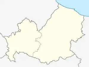 Sant'Angelo Limosano Sant'Angelo Limosano (Molise) | |
| Coordinates: 41°42′N 14°36′E / 41.700°N 14.600°E | |
| Country | Italy |
| Region | Molise |
| Province | Province of Campobasso (CB) |
| Area | |
| • Total | 16.8 km2 (6.5 sq mi) |
| Elevation | 900 m (3,000 ft) |
| Population (Dec. 2004)[2] | |
| • Total | 380 |
| • Density | 23/km2 (59/sq mi) |
| Time zone | UTC+1 (CET) |
| • Summer (DST) | UTC+2 (CEST) |
| Postal code | 86020 |
| Dialing code | 0874 |
Sant'Angelo Limosano is a comune (municipality) in the Province of Campobasso in the Italian region Molise, located about 15 kilometres (9 mi) northwest of Campobasso. As of 31 December 2004, it had a population of 380 and an area of 16.8 square kilometres (6.5 sq mi).[3]
Sant'Angelo Limosano borders the following municipalities: Fossalto, Limosano, Lucito, Salcito, San Biase, Trivento.
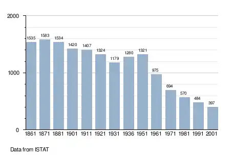
Demographic evolution
See also
References
- ↑ "Superficie di Comuni Province e Regioni italiane al 9 ottobre 2011". Italian National Institute of Statistics. Retrieved 16 March 2019.
- ↑ "Popolazione Residente al 1° Gennaio 2018". Italian National Institute of Statistics. Retrieved 16 March 2019.
- ↑ All demographics and other statistics: Italian statistical institute Istat.
This article is issued from Wikipedia. The text is licensed under Creative Commons - Attribution - Sharealike. Additional terms may apply for the media files.